Kislingbury
| Kislingbury | |
| Northamptonshire | |
|---|---|
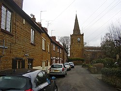
 Church Lane, Kislingbury | |
| Location | |
| Grid reference: | SP697594 |
| Location: | 52°13’46"N, 0°58’44"W |
| Data | |
| Population: | 1,237 (2011) |
| Post town: | Northampton |
| Postcode: | NN7 |
| Dialling code: | 01604 |
| Local Government | |
| Council: | West Northamptonshire |
| Parliamentary constituency: |
Daventry |
Kislingbury is a village in Northamptonshire about four miles west of Northampton town centre, and close to junctions 15A and 16 of the M1 motorway.
The village's name origin is uncertain. 'At the gravelly-place fortification' or perhaps, 'at the fortification of Cysel's people'.[1]
The 2011 census recorded a population of 1,237.
About the village
The village has three pub/restaurants, the most well-known being the Cromwell Cottage near the river, which has a tenuous historical connection with Oliver Cromwell: Parliamentarian forces spent a night nearby en route to the Battle of Naseby in 1645. The others are the Old Red Lion along the High Street and The Sun Inn on Mill Road.
The River Nene flows past the village close by to the north, through an old, narrow bridge – narrow, that is, for both vehicles and the river which frequently floods. The most recent serious incident in 1998 caused flood damage to several houses in the village. Some flood attenuation work has since been carried out but it remains to be seen if this proves adequate. The village carries heavy traffic being on a route to the larger village of Bugbrooke with the large Campion Secondary School which serves the village and a large catchment area around. Heavy vehicles from sand quarries in the area and also Heygates Flour Mill also use the village main road.
Outside links
| ("Wikimedia Commons" has material about Kislingbury) |