Kirtling
| Kirtling | |
| Cambridgeshire | |
|---|---|
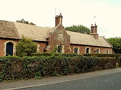
 Almshouses at Kirtling | |
| Location | |
| Grid reference: | TL687565 |
| Location: | 52°10’48"N, 0°28’12"E |
| Data | |
| Local Government | |
| Council: | South Cambridgeshire |
| Website: | Kirlting and Upend.org.uk |
Kirtling is a village in the southeast of Cambridgeshire, in the low hills along the Suffolk border against which the village nestles. To the north and south of Kirtling are the hamlets of Kirtling Towers and Kirtling Green respectively. The parish church stands in Kirtling Towers. A little further to the northeast is the village of Upend, with which Kirtling shares a civil parish.
From the 16th to the 19th century, Kirtling was known as Catlidge. Upend, on the other hand, was originally called Upheme - Old English for ‘the up-dwelling’. Upend may once have been a separate village but was absorbed into Kirtling parish before 1066, and Kirtling had become the most heavily populated parish in the neighbourhood in 1086.
A rich Cambridgeshire landowner named Oswi and his wife Leofflæd gave the parish of Kirtling to Ely Abbey around 1000. It later belonged to Earl (later king) Harold who died at the Battle of Hastings in 1066. By the time of the Domesday Book in 1086 it was probably held by an Englishman named Frawine of Kirtling.
The population of the parish had reached its peak of 1,458 by the 1801 census, and had fallen to 909 in 1851, below 800 in 1880, 600 in 1910, 500 in 1930 and to 300 in 1971.
Outside links
| ("Wikimedia Commons" has material about Kirtling) |