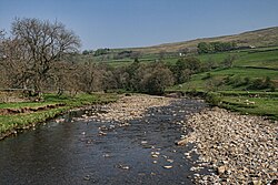
Kirkhaugh
| Kirkhaugh | |
| Northumberland | |
|---|---|
 River South Tyne from Kirkhaugh Bridge | |
| Location | |
| Grid reference: | NY696499 |
| Location: | 54°50’35"N, 2°28’23"W |
| Data | |
| Post town: | Alston |
| Postcode: | CA9 |
| Dialling code: | 01434 |
| Local Government | |
| Council: | Northumberland |
| Parliamentary constituency: |
Hexham |
Kirkhaugh is a very small village adjacent to the River South Tyne in Northumberland. The village lies close to the A689 road about two miles north of Alston across in Cumberland.
Contents
Transport
Although the Standard Gauge Alston Line from Haltwhistle to Alston passed through Kirkhaugh there was no station here when normal British Rail passenger services operated. The line opened in 1852 and closed in 1976.
Since 1983 a narrow gauge railway has opened on part of the original track bed. The railway, known as the South Tynedale Railway, is a 2-foot gauge line and runs two and a half miles from Alston to a station at Kirkhaugh and includes a viaduct over the River South Tyne. Efforts are being made to extend the line to Slaggyford.
Church
The church, rebuilt in 1869, is thought to be the only church dedicated to the Holy Paraclete.[1]
Outside links
| ("Wikimedia Commons" has material about Kirkhaugh) |
References
- ↑ Purves, Geoffrey (2006). Churches of Newcastle and Northumberland. Stroud, Gloucestershire, England: Tempus Publishing Limited. pp. 105. ISBN 0-7524-4071-3. http://www.tempus-publishing.com.
