Kirkcolm
| Kirkcolm | |
| Wigtownshire | |
|---|---|
 Main Street, Kirkcolm | |
| Location | |
| Location: | 54°57’54"N, 5°8’24"W |
| Data | |
| Local Government | |
| Council: | Dumfries and Galloway |
| Parliamentary constituency: |
Dumfries and Galloway |
Kirkcolm is a village on the northern tip of the Rhinns of Galloway in Wigtownshire. The parish forms a small peninsula, bounded on the north and west by the sea, on the east by the bay of Loch Ryan and on the south by the area of Leswalt. The number of acres under cultivation is between 10,000 and 11,000; there are upwards of 1200 acres waste and pasture, and between 100 and 200 planted.[1]
It was noted to have the best black Galloway cattle in the Rhinns.[1][2]
There was commercial salmon fishery in the north and herrings and oysters in Loch Ryan.
Contents
The Village
Blue Peter Hotel in Main Street was National Pub of the Year for Scotland and Northern Ireland in 2007.
Parish History
Kirkcolm, in Wigtownshire, means the Church of St Columba, thus leaving no doubt as to the dedication of its place of worship. The parish has a spring known as the Crosswell, or St. Columba's Well. Historically Kirkcolm has seen human activity since ancient times when it was known as Kirkcolm Parish. Sheltered from the rough seas of the North Channel and the North Atlantic the loch was, and is to the present time, an important safe harbour for vessels.
Lady Bay is near Corsewell House. Sir Herbert Maxwell wrote that the farm situated on this bay bore the Erse equivalent in its name, namely Portencalzie, (from the Irish Portan cailleach, meaning 'Port of the Nuns').
10th-century Viking Carved Stones are found in Kirkcolm churchyard. The cross originally stood close to St Mary's Chapel, Kilmorie (Cill Marie) which was next to St Mary's Well. It was later moved to the grounds of Corsewall House.[3] The cross was re-erected in the Kirkcolm churchyard in 1989. The designs on the magnificent Christian stone cross combines Christian and pagan Scandinavian images, reflecting Galloway's connections with its Viking and Celtic past. One face of the stone has an elaborately carved cross above a design of intertwined animal bodies, and the snake-like heads of some of the animals. On the reverse-side is a representation of the Crucifixion. Below is a figure of a man with a pair of tongs and a bird on his shoulder; this is most likely Sigurid, a super-hero from Viking mythology. It is thought the carvings on the Kilmorie Stone show the triumph of Christianity over paganism.
In the spring of 1307 at the beginning of Robert the Bruce military campaign, he sent two forces to attempt to gain control of Galloway. One force, led by his two brothers, consisting of eighteen galleys, landed in Loch Ryan.[4] They were immediately overwhelmed by local forces, led by Dougal MacDougal Clan MacDowall who was a supporter of the Comyns.
The Church
The Church of Scotland's old Parish Church of Kirkcolm (Kirk Of Kirkcolm) was in the grounds of Corsewall House, but was demolished in 1821 and a new church was built in Kirkcolm, up the hill from the old Kirk. The new chirch is named Kirkcolm Parish Church. The Kirk session, held in the court of the parish, was made up of he minister and the land owners and business men of the parish and dealt with moral issues, minor criminal cases, matters of the poor and education, matters of discipline, and the general concerns of the parish.
In 1636 sheriff Agnew of Wigtownshire acquired the Kirklands of Kirkcolm from John Gordon.
Places of Interest
Marian Tower The views from Marian Tower on Craigengerroch Hill above Drumdow are superb.
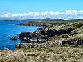
Corsewall Lighthouse a listed 'A' building of major national importance, stands on the north-west coast and the light beams a warning for ships and the new ferries approaching the mouth of Loch Ryan. Some of Scotland's most spectacular coastline is found within and near the Corsewall Light House Hotel. The lighthouse galleries and public areas afford fine views of the Kintyre Peninsula, Arran, the Firth of Clyde, Ailsa Craig and even the coast of Ireland. The Iron Age fort of Dunskirkloch is found here. A wide variety of flora, abundant sea life, seals, birds and even deer can be viewed from here. On a clear night, the beams of several Scottish and Irish lighthouses can be seen. The lighthouse was built in 1815 for the Commisssioners of Northern Lighthouses by Robert Stevenson, engineer father of Robert Louis Stevenson who wrote the novel "Kidnapped" . It was reported in a newspaper that scenes of the film "Kidnapped" were made near this locality.
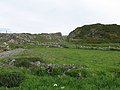
Corswall Castle (Corsewell Corsewall Krosswell) was owned by Alexander Campbell, a son of Sir Duncan Campbell of Loudoun, whose elder brother Andrew was Sheriff of Ayr. The lands are named from a hill (Cor-siale, " the round hill of the brine ") at the northern extremity of the Rhynns, against which the billows break in a north-western gale in one sweep from Labrador. Corswall Castle lay in a hollow behind it, the lower story vaulted and serving as a cow fort. This oblong keep once rose to three storeys and lay on a mound which was protected by a ditch. Now all that remains are the stumps of the four walls, which do not rise beyond a tunnel-vaulted basement. The wall still contains the lower section of a turnpike stair. A small cannon was discovered here in 1791, while a cache of gold coins, silver-plate and jewellery was uncovered in 1802.[5]
The castle was forsaken in favour of Corsewall House (by Kirkcolm) by the 18th Century. A preposterous story passes current that in the well underneath this was a spring of such power that by raising the lid the owners could at pleasure flood the moat and approaches to the castle ; the origin of which seems a stone lying upon another, and many chisel-shaped stones lay on the beach below it.[6] The ruin of Corsewall (written Corsill) or Corswell Castle is shown on National Library of Scotland, John Ainslie map AD1782 [7] and Krosswell (Corsewall), in this Parish, is on the two 1684 Pont's maps in the Bleau Atlas.[8]
History
In 1623 Alexander Stewart, 1st Lord Garlies was created Earl of Galloway and in AD1627 he was created Baron of Corsewell, Kirkcolm Wigtownshire. On 17 July 1632, Alexander, Lord Stewart of Garlies (created Earl of Galloway on 19 September following) had a charter of the barony of Corswall, with the castle, etc. which was confirmed by Act of the Parliament of Scotland on 20 June 1633.[9] Between AD1619-1623 Lord Garlies negotiated with James Stewart, Lord Ochiltrie, for the latter's barony of Corswell. On 17 July 1623 he had a grant of the barony of Corsewell with a grant of burgh of barony to be called the Burgh of Stewarton conveninetly situated for a burgh and spacious and commodious harbour on the coast between Scotland and Ireland. Stewarton was renamed Kircolm Village. Ainslie's 1782 map showed Lady Galloway (of the Earl of Galloway, Stewart family) at "Fine View", Kirkcolme, and Rev. Andrew Ross at Barsalloch. "Fine View" was probably known as "Corsewell House".[10]
John and James Ross
Admiral Sir John Ross (1777 – 1856), the famed Arctic explorer was born in Kirkcolm, but later moved to Stranraer.[11] After many years of famous exploits in the Arctic, initially along with his equally famous nephew, James Ross, he retired home. In 1849 aged about 62 years, he had a grant from the Hudson's Bay Company and fitted out the vessel "Felix" which sailed from Stranraer on 23 May 1850. He spent his retirement years at North West Castle his house at the head of Loch Ryan.
Admiral Sir James Clark Ross (1800 - 1862), John Ross's nephew, was the man who discovered the magnetic north pole amongst the wastes of what became Canada. He too was a man of Kirkcolm. James Ross also explored the Antarctic Seas; the Ross Ice Shelf and New Zealand's Ross Dependency are named after him.
Pictures
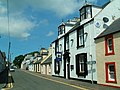
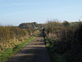
Blue Peter Hotel, Main Street, Kirkcolm
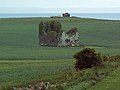
Remains of Corsewall Castle 15th century ruin
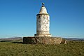
Marian Hill Monument on Craigengerroch Hill above Drumdow

Jamieson's Point fort, Loch Ryan

Left of photo is the site of Caspin promontory fort
Site of Dunskirloch Iron-age Promontory Fort, Corsewall Point
site of Doonan of Dally fort, Dounan Bay
Castle Ban Motte (possibly Dounan of Airies)
Site of Drundream fort, Kirkcolm
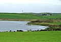
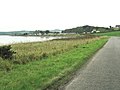
Loch Connell
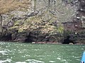
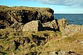
Sea Caves at the foot of Sea Cliff, Loch Ryan
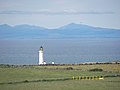
Corsewall Lighthouse from Cairnside Farm
Cairnside Farm: Ireland seen on the horizon
Cairnside Farm: Kintyre seen on the horizon
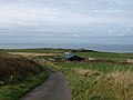
Marslauch near Kirkcolm
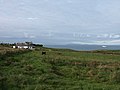
Near St Mary's well


| ("Wikimedia Commons" has material about Kirkcolm) |
References
- ↑ 1.0 1.1 A Topographical Dictionary of Scotland by Samuel Lewis. pub. 1846
- ↑ Ervie-Kirkcolm Church of Scotland: history
- ↑ Corsewall Estate History
- ↑ Project Adair: RCAHMS
- ↑ http://www.scottish-places.info/parishes/parmap1046.html
- ↑ Agnew, Andrew: 'The Hereditary Sheriffs of Galloway; Vol. I, page 218
- ↑ John Ainslie map, 1782; NLS
- ↑ 1684 Pont maps in the Bleau Atlas; NLS
- ↑ History of the lands and Their Owners in Galloway by P.H. M'Kerlie. New Edition. volume 1. pub. 1906, p.403
- ↑ History of Galloway. by William Mackenzie. vol.II. p.83 http://archive.org/stream/historyofgallowa02mack#page/82/mode/2up/search/Dalrymple
- ↑ Visit Stranraer and the Rhins – Kirkcolm