Difference between revisions of "Kintail"
(Created page with '{{Infobox NT |name=Kintail |county=Inverness-shire |town= |picture=Five Sisters.jpg |picture caption=Four of the Five Sisters of Kintail from Shiel Bridge |type=estate |os grid r…') |
|||
| Line 1: | Line 1: | ||
{{Infobox NT | {{Infobox NT | ||
|name=Kintail | |name=Kintail | ||
| − | |county=Inverness-shire | + | |county 1=Ross-shire |
| + | |county 2=Inverness-shire | ||
|town= | |town= | ||
|picture=Five Sisters.jpg | |picture=Five Sisters.jpg | ||
| Line 9: | Line 10: | ||
|website={{NT link|Kintail and Morvich}} | |website={{NT link|Kintail and Morvich}} | ||
}} | }} | ||
| − | '''Kintail''' is a mountainous area of [[Inverness-shire]]. Much of the landscape is owned by the [[National Trust for Scotland]]. | + | '''Kintail''' is a mountainous area of [[Ross-shire]] and [[Inverness-shire]]. Much of the landscape is owned by the [[National Trust for Scotland]]. |
| − | Kintail consists of the mountains to the north of [[Glen Shiel]] (and the A87 road) between the heads of [[Loch Duich]] and [[Loch Cluanie]]; its boundaries, other than [[Glen Shiel]], are generally taken to be the valleys of Strath Croe and Gleann Gaorsaic to the north and An Caorann Mòr to the east. | + | Kintail consists of the mountains to the north of [[Glen Shiel]] (and the A87 road) between the heads of [[Loch Duich]] and [[Loch Cluanie]]; its boundaries, other than [[Glen Shiel]], are generally taken to be the valleys of Strath Croe and Gleann Gaorsaic to the north and An Caorann Mòr to the east. The area is split between the parishes of Glen Shiel and Kintail, with the latter lying to the north of the glen. |
==Geography== | ==Geography== | ||
| + | {{Main|Glen Shiel Hills}} | ||
The area is known chiefly for the '''Five Sisters Of Kintail''' ({{lang|gd|Còig Peathraichean Chinn Tàile}}, although not a name derived from Gaelic, it has individual names for each of the five sisters: | The area is known chiefly for the '''Five Sisters Of Kintail''' ({{lang|gd|Còig Peathraichean Chinn Tàile}}, although not a name derived from Gaelic, it has individual names for each of the five sisters: | ||
| Line 23: | Line 25: | ||
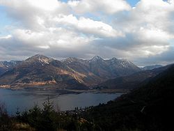
[[File:Five Sisters of Kintail.jpg|right|thumb|250px|Five Sisters of Kintail from Mons Rattagan]] | [[File:Five Sisters of Kintail.jpg|right|thumb|250px|Five Sisters of Kintail from Mons Rattagan]] | ||
| − | These mountains form a high ridge some | + | These mountains form a high ridge some five miles long rising steeply from Glen Shiel to a maximum height of 3,501 feet. The five distinctly pointed summits are a well-known landmark and a popular hillwalking expedition. Three of the Five Sisters, which are all over 3,000 feet, are classified as full [[Munro]]s, with the other two being subsidiary [[Munro]] tops. The ridge containing the Five Sisters continues unbroken to the east where it takes in a further three Munros, often known as the Brothers. [[Beinn Fhada]] (Ben Attow) is the other main mountain in the area. |
==Ownership== | ==Ownership== | ||
| Line 29: | Line 31: | ||
==Outside links== | ==Outside links== | ||
| + | *Location map: {{wmap|57.20583|-5.35222|zoom=14}} | ||
*{{NT link|Kintail and Morvich}} - National Trust for Scotland | *{{NT link|Kintail and Morvich}} - National Trust for Scotland | ||
* [http://kintail.walkhighlands.co.uk/ Kintail guide (with walking routes)] | * [http://kintail.walkhighlands.co.uk/ Kintail guide (with walking routes)] | ||
| − | |||
| − | |||
Latest revision as of 19:05, 12 June 2015
| Kintail | |
| National Trust for Scotland | |
|---|---|
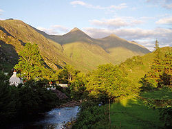
 Four of the Five Sisters of Kintail from Shiel Bridge | |
| Grid reference: | NH025160 |
| Information | |
| Website: | Kintail and Morvich |
Kintail is a mountainous area of Ross-shire and Inverness-shire. Much of the landscape is owned by the National Trust for Scotland.
Kintail consists of the mountains to the north of Glen Shiel (and the A87 road) between the heads of Loch Duich and Loch Cluanie; its boundaries, other than Glen Shiel, are generally taken to be the valleys of Strath Croe and Gleann Gaorsaic to the north and An Caorann Mòr to the east. The area is split between the parishes of Glen Shiel and Kintail, with the latter lying to the north of the glen.
Geography
- Main article: Glen Shiel Hills
The area is known chiefly for the Five Sisters Of Kintail (Gaelic: Còig Peathraichean Chinn Tàile, although not a name derived from Gaelic, it has individual names for each of the five sisters:
- Sgùrr na Ciste Duibhe
- Sgùrr na Càrnach
- Sgùrr Fhuaran
- Sgùrr nan Spàinteach
- Sgùrr nan Saighead
These mountains form a high ridge some five miles long rising steeply from Glen Shiel to a maximum height of 3,501 feet. The five distinctly pointed summits are a well-known landmark and a popular hillwalking expedition. Three of the Five Sisters, which are all over 3,000 feet, are classified as full Munros, with the other two being subsidiary Munro tops. The ridge containing the Five Sisters continues unbroken to the east where it takes in a further three Munros, often known as the Brothers. Beinn Fhada (Ben Attow) is the other main mountain in the area.
Ownership
Most of Kintail is owned by the National Trust for Scotland. The Trust's Kintail and Morvich estate covers 29 square miles and includes the Falls of Glomach, one of the highest waterfalls in Great Britain. The estate was bought for the Trust in 1944 by Percy Unna, the Scottish Mountaineering Club president who also acquired Glencoe for the Trust.
Outside links
- Location map: 57°12’21"N, 5°21’8"W
- Kintail and Morvich - National Trust for Scotland
- Kintail guide (with walking routes)
