Kinder Scout
| Kinder Scout | |||
| Derbyshire | |||
|---|---|---|---|
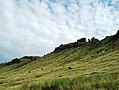
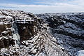
 The Kinder plateau seen from the south | |||
| Range: | Peak District | ||
| Summit: | 2,087 feet SK086875 53°23’3"N, 1°52’20"W | ||
Kinder Scout is a high moorland plateau in the Dark Peak of the Derbyshire Peak District. Part of the moor, at 2,087 feet above sea level, is the highest point Derbyshire, the county top, and the highest point in the whole of the Peak District. It is owned by the National Trust.
Kinder Scout may be climbed from the villages of Hayfield and Edale nearby and it has long been a favourite weekend climb for visitors: its popularity amongst the factory workers of the south Lancashire mill towns led to the Kinder Scout Mass Trespass in 1932 and the movement to open the moorlands up to walkers.
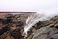
The hill is named after the waterfall now known as Kinder Downfall but formerly named Kinder Scout: a 100-foot waterfall on the moor. The name is said to be derived from Old Norse, meaning “water over the edge”. There was too a village of Kinder which once lay on the slope of the peak and which is listed in the Domesday Book of 1086.
The history and meaning of the name have been studied by Broderick [1]
To the north of Kinder Scout across the Snake Pass lie the high moors of Bleaklow and then Black Hill in Cheshire, which are of similar height.
Kinder Scout is a popular hiking location. The Pennine Way crosses Kinder Scout and the moors to the north, which has resulted in the erosion of the underlying peat, prompting work by the council and the Peak District National Park to repair it, in conjunction with the landowner, the National Trust.[2]
Contents
Public access
For many years, workers in the factories of Manchester and the surrounding mill towns of south Lancashire used to come to Kinder Scout and the surrounding fells at the weekends. In time though local landowners became concerned and erected new fences and warning signs to keep these unwelcome visitors off their land. The commonplace signs, ‘’Trespasses will be prosecuted’’ were nicknamed “wooden liars”, as trespass itself is not a criminal act.
In response, Kinder Scout was the target of an organised mass trespass in 1932. The result was the beginning of a national movement to improve access to the countryside; new footpaths were created and the National Parks movement began. From the creation of the Peal District National Park, a large area of the high moorland north of Edale was designated as 'Open Country'. In 2003, a "right to roam" on uncultivated land was granted by law, and this area of open country has been significantly extended.
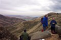
In fine weather conditions the city of Manchester and its surrounding towns can be seen, and as far as Winter Hill near Bolton, and the mountains of Snowdonia.
Kinder Downfall
Kinder Downfall is the tallest waterfall in the Peak District, with a 100-foot fall. It lies on the River Kinder, where it flows west over the edge of Kinder Scout. The waterfall was formerly known as Kinder Scut, and it is from this that the plateau derives its name.
Although usually little more than a trickle in summer, in spate conditions Kinder Downfall is impressive. In certain wind conditions (notably when there is a strong west wind), the water is blown back on itself, and the resulting cloud of spray can be seen from several miles away.
In cold winters the waterfall freezes providing local mountaineers an icy challenge that can be climbed with ice axes, ropes and crampons. Below the Downfall the River Kinder flows into Kinder Reservoir.
Edale Cross

The Edale Cross lies immediately south of Kinder Scout, under Kinder Low and on the former Hayfield to Edale road. It marks the former junction of the three wards of the Forest of Peak: Glossop and Longdendale, Hopedale and Campagna. The first cross on the site might have been set up by the Abbots of Basingwerk Abbey to mark the southern boundary of their land, granted in 1157.
The date of the current cross is unknown, although a plaque beside it claims it to be mediæval. At some point it fell down, and was re-erected in 1810, when the date and initials JG, WD, GH, JH and JS were carved into it, which stand for John Gee, William Drinkwater, George and Joseph Hadfield and John Shirt, local farmers who raised the cross.[3]
Outside links
| ("Wikimedia Commons" has material about Kinder Scout) |
- Computer-generated summit panoramas Kinder Scout index. Note: the panorama shown is not all visible from the summit. There is a large summit plateau; to see the entire panorama shown, it is necessary to walk around the summit but nearer the perimeter of the plateau.
- The Mass Trespass. National Trust web site about the 1932 trespass on to Kinder Scout
- Hayfield Village - the gateway to Kinder Scout
Picture gallery
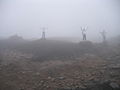
Poor visibility near the summit
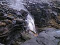
Kinder Downfall
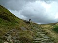
Ascending Jacob's Ladder towards Kinder Low trigpoint
Hags and groughs on the Kinder plateau
North flank of Kinder Scout SK075900
Kinder Downfall in strong west wind
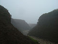
Head of Grindsbrook
Panoramic View over Kinder Reservoir from Kinder
Ice climbers on Kinder Downfall


References
- ↑ Broderick, George "Kinder Scout", Journal of the English Place-name Society, volume 42, 63-74 (2010)
- ↑ Peak District National Park Authority, Landscape Strategy and Action Plan, September 2009 (section on Dark Peak)
- ↑ Neville T. Sharpe, Crosses of the Peak District (Landmark Collectors Library, 2002)