Kimberworth
| Kimberworth | |
| Yorkshire West Riding | |
|---|---|
 Kimberworth Manor House | |
| Location | |
| Grid reference: | SK401932 |
| Location: | 53°25’22"N, 1°24’15"W |
| Data | |
| Post town: | Rotherham |
| Postcode: | S61 |
| Dialling code: | 01709 |
| Local Government | |
| Council: | Rotherham |
| Parliamentary constituency: |
Rotherham |
Kimberworth is a village of the West Riding of Yorkshire that has become a suburb of Rotherham. It is located about two miles north-west of Rotherham town centre and four and a half miles north-east of the City of Sheffield.
History
Kimberworth is mentioned in the 1086 Domesday Book, where it is noted as "Chiberworde". Kimberworth Castle, near The Drawbridge pub. The monks at nearby Kirkstead Abbey were smelting iron from around 1160, the rest of the history of this area is heavily influenced by industrial developments, especially in iron, steel and coal.
There is evidence of human activity in this area going back 5,000 years.
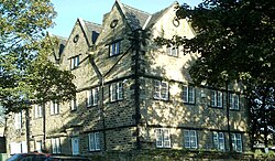
The present manor house at Kimberworth was built in 1694 by the Kent family, long prominent at Kimberworth, who married with, amongst others, the Rawson family of Upperthorpe and the Creswick family that had owned land at Owlerton since the fourteenth century.
Churches
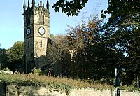
The Kimberworth area has several churches, the most prominent being St Thomas's Anglican Church on Church Street, construction of which was started in 1842. The Salvation Army has a meeting hall on High Street, this is also used by the 1st Rotherham Cub Scout pack. Kimberworth United Reformed Church met in a building on Kimberworth Road overlooking Bradgate Park (Church closed in 2010). The church is now demolished.
Pictures=
| ("Wikimedia Commons" has material about Kimberworth) |
Outside links
- Kimberworth in the Domesday Book

