Killen, Tyrone
From Wikishire
| Killen | |
| Tyrone | |
|---|---|
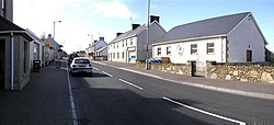
 Main Street in Killen. | |
| Location | |
| Grid reference: | H240806 |
| Location: | 54°40’32"N, 7°37’30"W |
| Data | |
| Population: | 231 (2001) |
| Post town: | Castlederg |
| Postcode: | BT81 |
| Dialling code: | 028 |
| Local Government | |
| Council: | Derry and Strabane |
| Parliamentary constituency: |
West Tyrone |
Killen is a small village and a townland of 356 acres in Tyrone. It is several miles south-west of Castlederg, on the road leading south over Scraghy Mountain. A short distance to the west lies the border with the Republic of Ireland (County Donegal). It is in the Barony of Omagh West.
The 2001 Census recorded a population of 231 people.
In recent years, Killen Creamery has been turned into a community centre and business centre. Killen also has an Orange Lodge, which was founded in 1829.
| ("Wikimedia Commons" has material about Killen, Tyrone) |