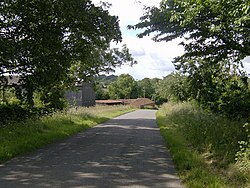
Ketsby
From Wikishire
Revision as of 13:32, 25 November 2020 by RB (Talk | contribs) (Created page with "{{Infobox town |name=Ketsby |county=Lincolnshire |picture=Farm buildings at Ketsby - geograph.org.uk - 482296.jpg |picture caption=Ketsby |os grid ref=TF368765 |latitude=53.2...")
| Ketsby | |
| Lincolnshire | |
|---|---|
 Ketsby | |
| Location | |
| Grid reference: | TF368765 |
| Location: | 53°16’7"N, 0°3’5"E |
| Data | |
| Post town: | Louth |
| Postcode: | LN11 |
| Local Government | |
| Council: | East Lindsey |
| Parliamentary constituency: |
Louth and Horncastle |
Ketsby is a hamlet in Lindsey, the northern part of Lincolnshire, and is to be found five miles west of Alford.
The Greenwich Meridian line passes through the hamlet.
History and heritage
Ketsby is listed in the Domesday Book account with 18 households, a meadow of 60 acres and a mill.[1]
An early mediæval cresset lamp, with a maltese cross carved on the base, was found at Ketsby and is now in Lincoln City and County Museum.[2]
Ketsby water mill and mill house are built in yellow brick, date from 1864, and are Grade II listed buildings. The mill is no longer in operation.[3][4]
Outside links
| ("Wikimedia Commons" has material about Ketsby) |
References
- ↑ Ketsby in the Domesday Book
- ↑ National Monuments Record: No. 893248 – Cresset Lamp, Ketsby
- ↑ National Heritage List 1168628: Ketsby Water Mill (Grade II listing)
- ↑ National Heritage List 1359698: Ketsby Mill House (Grade II listing)