Kelby
From Wikishire
Revision as of 13:44, 18 June 2019 by Owain (Talk | contribs) (Created page with "{{Infobox town |county=Lincoln |picture=St.Andrew's church, Kelby, Lincs. - geograph.org.uk - 130284.jpg |picture caption=St Andrew's Church, Kelby |latitude=52.960976 |longit...")
| Kelby | |
| Lincolnshire | |
|---|---|
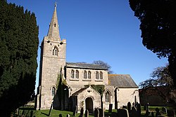
 St Andrew's Church, Kelby | |
| Location | |
| Grid reference: | TF004414 |
| Location: | 52°57’40"N, 0°30’21"W |
| Data | |
| Post town: | Grantham |
| Postcode: | NG32 |
| Dialling code: | 01400 |
| Local Government | |
| Council: | North Kesteven |
| Parliamentary constituency: |
Sleaford and North Hykeham |
Kelby is a hamlet in the ancient parish of Heydour, in the Kesteven part of Lincolnshire. It is situated five miles south-west of Sleaford, nine miles north-east of Grantham and three miles south-east of Ancaster. It lies in the wapentake of Aswardhurn, along with neighbouring Culverthorpe, the two having formed the civil parish of Culverthorpe and Kelby since 1931.
Kelby church is dedicated to St Andrew and was previously a chapelry of Heydour.[1] Its tower was rebuilt in 1881 after a collapse. The church basement is Norman and the font Early English, with pews originally from the chapel at nearby Grade-II-listed Culverthorpe Hall.[2][3]
A chapel for Primitive Methodists was established in 1859.[1]