Difference between revisions of "Islay"
(Created page with '{{Infobox island |name=Islay |gaelic=Ìle |county=Argyllshire |group=Inner Hebrides |map=Islay.svg |picture=Port Charlotte - Loch Indall.JPG |picture caption=Port Charlotte and L…') |
|||
| Line 4: | Line 4: | ||
|county=Argyllshire | |county=Argyllshire | ||
|group=Inner Hebrides | |group=Inner Hebrides | ||
| − | |map=Islay.svg | + | |map=Islay Inner Hebrides.svg |
|picture=Port Charlotte - Loch Indall.JPG | |picture=Port Charlotte - Loch Indall.JPG | ||
|picture caption=Port Charlotte and Loch Indall | |picture caption=Port Charlotte and Loch Indall | ||
Latest revision as of 22:51, 13 March 2020
| Islay Gaelic: Ìle | |
 Port Charlotte and Loch Indall | |
|---|---|
| Main village: | Bowmore |
| Location | |
|
| |
| Grid reference: | NR370598 |
| Area: | 239 square miles |
| Highest point: | Beinn Bheigeir, 1,611 feet |
| Data | |
| Population: | 3,457 |

Islay is a large island in the Inner Hebrides belonging to Argyllshire.
Islay is known as "The Queen of the Hebrides". It is the southernmost of the great isles of the Hebrides, lying just west of Jura and around 25 miles north of Rathlin Island, off the coast of Antrim, which can be seen on a clear day.
In Gaelic a native of Islay is called an Ìleach (and the plural is Ìlich). Gaelic is spoken by about a third of the population.
The island's capital is Bowmore where the distinctive round Kilarrow Parish Church and a distillery are located. Port Ellen is the main port.
Islay is the fifth largest Scottish island and the sixth largest island surrounding Great Britain. It has just over three thousand inhabitants. It has a total area of 239 square miles. Its main industries are the making of malt whisky and tourism, which is often drawn by whisky and birdwatching as much as by the beauties of the isle.
The climate on Islay is often more clement than that of the Argyllshire mainland as the island is washed by the Gulf Stream.
Contents
Wildlife
Birds
The island is home to many bird species and is a popular destination throughout the year with birdwatchers, especially in autumn and winter to see the wintering population of Greenland white-fronted and barnacle geese. Resident birds include red-billed chough, hen harrier, white-tailed eagle, golden eagle, oystercatcher, cormorant and many wading birds.
Also found on the island in numbers and in its seas are shags, buzzards, peregrine falcons, rock doves, guillemots, razorbills, black guillemots and ravens.
Beasts and butterflies
Islay is home to many different species of wildlife beyond the rich bird colonies. In the seas are grey seals and otters and on the glens red deer, and adders. The island supports a significant population of the marsh fritillary butterfly.
Geography

The island's population is mainly centred around the villages of Bowmore, Port Ellen and Port Charlotte. Other smaller villages include Portnahaven, Bridgend, Ballygrant and Port Askaig. The rest of the island is sparsely populated and mainly agricultural.
The south-western end of the main body is a largely rocky region called The Oa. The north western arm of the island is called the Rhinns of Islay.
The island has no great landfast lochs but several lesser waters including Loch Finlaggan, Loch Ballygrant, Loch Lossit and Loch Gorm.
The coastline is cliff-bound and beaten into numerous bays and sea lochs including Loch Gruinart, Loch Indaal, Loch an t-Sailein, Aros Bay and Claggain Bay.
Loch Indaal, which separates the Rhinns of Islay from the rest of the island, is formed along a branch of the Great Glen Fault called the Loch Gruinart Fault, the main line of which passes just to the north of Colonsay. This separates the limestone, igneous intrusions and Bogh Mor sandstones from the Colonsay group rocks of the Rhinns.[1] The result is occasional, minor earth tremors.[2] Ardnave Point is a conspicuous promontory on the northwest of Islay.
There are no Munros on Islay as there are not on Jura. The highest peak of Islay is Beinn Bheigier at 1,612 feet.
There are numerous burns throughout the island, many of which despite their small size, bear the name 'river'. The most significant of these are the River Laggan which discharges into the sea at the north end of Laggan Bay and the River Sorn which, draining Loch Finlaggan, enters the head of Loch Indaal at Bridgend.
Prehistory
The earliest trace of man on Islay is a Mesolithic flint arrowhead found near Bridgend in 1993 dating from 10,800 BC - the oldest in Scotland. Other finds have been dated to 7000 BC using radiocarbon dating of shells and debris from kitchen middens.[3][4] By the Neolithic, settlements had become more permanent,[5] allowing for the construction of several communal monuments.[6]
History

Recorded history begins with a document relating to St Columba[7] who probably passed through Islay on his way to establish the monastery on Iona in the 6th century. At this time, Islay lay within the kingdom of Dál Riata and was ruled by the Cenél nÓengusa.
From the 14th to the 16th centuries, Islay, along with the rest of the Hebrides Archipelago and much of the west coast of Scotland, was controlled by Clan Donald, whose chief became known as the Lord of the Isles. The Islay Charter, a record of lands granted to an Islay resident, Brian Vicar MacKay, by the Domhnall of Islay, Lord of the Isles in 1408, is one of the earliest records of Scottish Gaelic in public use, and is a significant historical document.[8]
The MacDonald Lords commanded a strong semi-independent maritime kingdom during the Middle Ages, and considered themselves equals of the kings of Scotland, Norway, and England.[7] Their base of power was a large Gaelic settlement on the shores of Loch Finlaggan in northeastern Islay, near the present-day village of Caol Ila. The origins of the Lordship date back to the defeat of the Danes off the coast of Islay in 1156 by Somerled, but some evidence suggests that Finlaggan was a place of inauguration long before them.
Writing in 1549, Dean Monro wrote:
In this iyle there is strenths castells; the first is callit Dunowaik, biggit on ane craig at the sea side, on the southeist part of the countery pertaining to the Clandonald of Kintyre; second is callit the castle of Lochgurne, quhilk is biggit ill ane iyle within the said fresche water loche far fra land, pertaining of auld to the Clandonald of Kintyre, now usurped be M’Gillayne of Doward. Ellan Forlagan, in the middle of Ila, ane faire iyle in fresche water.[9][10]
Each successive chief of Clan Donald was proclaimed Lord of the Isles upon an ancient seven-foot-square coronation stone at Finlaggan. Like the ritual stone at Dunadd, capital of Dál Riata, it contained footprint impressions in which the new ruler stood barefoot and, with his father's ceremonial stone in his hand, was anointed by the Bishop of Argyll and seven priests. During the ceremony an orator recited a list of the Lord's ancestors and he was proclaimed "Macdonald, high prince of the seed of Conn".[11]
In 1462, John MacDonald II (also known as John of Islay, Earl of Ross), the last and most ambitious of the Lords, struck an alliance with Edward IV of England with the goal of conquering Scotland. However it was ill-timed for the Wars of the Roses burst out in England and prevented Edward from fulfilling his obligations as an ally. In 1493 John Macdonald was compelled to forfeit his estates and titles to James IV of Scotland. After the forfeiture, James ordered that Finlaggan be demolished, its buildings razed, and the coronation stone destroyed to discourage any attempts at restoration of the Lordship.[7] The title itself survived, however; today, the heir to the British throne, who is known as the Prince of Wales in all other parts of the British Commonwealth, bears the title Lord of the Isles within Scotland.[12]
In 1726, the island was purchased by Daniel Campbell (d. 1753) of Shawfield for £12,000. It remained in his family's ownership until 1853 when it was sold to James Morrison, the grandfather of the first Baron Margadale. Starting in the 1830s, the population of the island began dropping from its peak of 15,000 as a result of the Highland Clearances. Today's population is about 3,000. Most emigrants from Islay made new homes in Ontario, the Carolinas (in the United States) and Australia.
During Second World War, the Royal Air Force built an airfield at Glenegedale which later became the civil airport for Islay. There was also an RAF Coastal Command flying boat base at Bowmore from 13 March 1941 using Loch Indaal, flying Short G Boat, Short C Boat (the precursor of the Sunderland) and Catalina I.[13] On 1 September 1942 a reformed 246 Squadron with Sunderland Mark III aircraft took over.[14] In May, 1943, RCAF 422 Squadron moved to Lochindall at Bowmore with Sunderland Aircraft.[15] The 1942 film "Coastal Command" was partly filmed in Bowmore.[16]
There was a RAF Chain Home radar station at Saligo Bay and RAF Chain Home Low radar station at Kilchiaran which became a RAF ROTOR radar station in the 1950s.
In the early 21st century, a campus of Sabhal Mòr Ostaig was set up on Islay, Ionad Chaluim Chille Ìle.
Economy
Distilleries

Islay malt whisky is produced by eight distilleries on the island.
The distilleries on the south of the island produce whiskies with a very strong peaty flavour. From east to west they are Ardbeg, Lagavulin, and Laphroaig (which are considered to be among the most intensely flavoured of all whiskies). On the north of the island Bowmore, Bruichladdich and Bunnahabhain are produced. These whiskies are substantially lighter in taste. Caol Ila is an exception, produced in the north but flavoured more strongly of iodine and peat and thus closer in taste to Islay's southern malts.[17]
There were more distilleries in the past: the Lochindaal in Port Charlotte closed as long ago as 1929 and Port Ellen closed in 1983 and. Little blending is done on the island, though since the takeover of Bruichladdich distillery by several private individuals whisky is now blended and bottled there by a Master Distiller. Bruichladdich is also noteworthy as the only distillery which bottles its malts on Islay.
In 2005, a new microdistillery opened at Rockside Farm. Named Kilchoman Distillery, it officially opened in June, and distilled its first spirit in November. The malting floor burned down in February 2006, but has since been repaired and is back to full operation.
In March 2007 Bruichladdich announced that it would reopen Port Charlotte Distillery, using equipment from the Inverleven distillery. The distillery will use the existing warehouses of the former Lochindaal Distillery while a visitor centre will be built on the current site of Clyne's Garage. The rebuilt distillery will be named Lochindaal as well.[18]
Brewery
Apart from the whisky there is now an original real ale from the Isle of Islay. The Islay Ales Brewery opened its doors on 22 March 2004 and brews seven different real ales,[19] some of which are seasonal, or for special occasions such as the yearly Festival of Malt and Music. The brewery is located on Islay House Square just outside Bridgend.
Renewable energy
Islay’s place, exposed to the full force of the North Atlantic, has led to its being the site of a pioneering wave power station near Portnahaven. The Islay LIMPET (Land Installed Marine Powered Energy Transformer) wave power generator was designed and built by Wavegen and researchers from the Queen's University of Belfast, and was financially backed by the European Union. Known as Limpet 500, due to cabling constraints its capacity is limited to providing up to 150 kW of electricity into the island's grid.[20] In 2000 it became the world's first commercial wave power station.
In March 2011 the largest tidal array in the world was approved, with 10 planned turbines predicted to generate enough power for over 5,000 homes. The project will be located in the Sound of Islay which offers both high currents and shelter from storms.[21]
Fishing

Islay has some of the finest brown trout fishing in Europe. Imported rainbow trout have not been released on the island and the "brownies" still dominate the freshwater ecosystems. In 2003 the European Fishing Competition was held on five of the lochs. Most of the estates organise fishing on the rivers and lochs and maintain the banks for fishing. Sea angling is also popular especially over the many shipwrecks around the coast.
Tourism
The Finlaggan Trust has a visitor centre which is open on some days of the week.
Transport
Many of the roads on the island are single-track with passing places. The two main roads are the A846 from Ardbeg to Port Askaig via Port Ellen and Bowmore, and the A847 down the east coast of the Rhinns.
The island has its own airport, Glenegedale Airport with services to and from Glasgow.
There are regular ferry services to Port Ellen and Port Askaig from Kennacraig, taking about two hours. Services to Port Askaig also sail on to Scalasaig on Colonsay and on to Oban on Wednesdays during the summer only. A ferry sails also from Port Askaig to Feolin on Jura.
Churches

Kilarrow Parish Church (also known as the Round Church) is round, legend has it, to leave no corner for the devil to hide in.
The kirk on the Rhinns of Islay is just outside the village of Port Charlotte. Known as St Kiaran's, the ministry is shared with the Kilmeny congregation. St John's Church of Scotland, Port Ellen is exploring a possible linkage with Kilarrow and is currently being served by a locum. Each of the vacant Church of Scotland congregations has an Interim Moderator who is responsible for the oversight of the congregation.
There are several other congregations on Islay. Baptists meet in the mornings in Port Ellen and in the evenings in Bowmore. The Scottish Episcopal Church of St Columba is located in Bridgend.
Many old church buildings on Islay are in an unroofed and ruined state; some have considerable historical interest dating from mediæval times. The ruined church of Kildalton has one of the finest carved crosses in the world; dating to the 8th century, it is carved out of the local bluestone. A carved cross of similar age, but much more heavily weathered can be found at Kilnave.[22] Associated with many churches are mysterious cupstones which date to prehistory; these can be seen at Kilchoman Church where the carved cross there is erected on one, at Kilchiaran Church on the Rhinns and at other sites. Several more recently abandoned churches have been adapted as dwellings.
Gallery
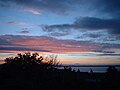
Sunset over the Rhinns of Islay
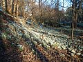
Bridgend woods in January 2006
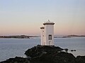
The lighthouse at Carraig Fhada
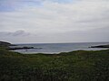
Sanaigmore Bay in Autumn


Outside links
| ("Wikimedia Commons" has material about Islay) |
- Islay & Jura Islay and Jura Tourism and Marketing Group information about visiting Islay
- Islay's Ultimate Online Guide A wealth of information and pictures
- The Islay Guide A comprehensive guide to what to see and do on Islay
- The Islay Directory
- John Carmichael Mac'illeMhìcheil A link to the BBC program website
- The Ileach, the local newspaper
- Islay Wildlife, the Islay Natural History Trust
- Islay Guide in pictures Discover Islay, its people, beaches, whisky and art
- Islay message boards at RootsWeb.com
- VisitScotland Islay Video Report
- The Islay Ferry - Past and Present
- The Islay Energy Trust - renewable energy
References
- ↑ "map" (PDF). http://eprints.gla.ac.uk/225/01/Thomas%5B1%5D.pdf. Retrieved 2008-01-23.
- ↑ "Jura Earthquake 3 May 1998". British Geological Survey. http://www.earthquakes.bgs.ac.uk/macroseismics/jura_macro.htm. Retrieved 2008-01-23.
- ↑ Storrie (1997) p. 28
- ↑ Jupp (1994) p. 10
- ↑ Storrie (1997) p. 29
- ↑ Jupp (1994) p. 11
- ↑ 7.0 7.1 7.2 "Finlaggan Trust". http://www.finlaggan.com/. Retrieved 2008-01-23.
- ↑ David Ross (10 May 2007). "Gaelic documents may return north". The Herald. http://www.theherald.co.uk/news/news/display.var.1387482.0.0.php. Retrieved 2008-01-23.
- ↑ Monro (1549) "Ila" No. 55
- ↑ "The Centre of the Lordship of the Isles". Finlaggan Trust. Retrieved 3 April 2011.
- ↑ Bord, Janet & Colin (1976). The Secret Country. London: Paul Elek. ISBN 0-236-40048-7; pp. 66-67
- ↑ Dunbar, J. The Lordship of the Isles in The Middle Ages in the Highlands. Inverness Field Club, 1981 ISBN 978-0-9502612-1-8.
- ↑ "No 119 Squadron RAF". http://www.rafcommands.com/Coastal/119C.html. Retrieved 2008-01-23.
- ↑ "No.246 Squadron RAF". http://www.rafcommands.currantbun.com/Coastal/246C.html. Retrieved 2008-01-23.
- ↑ "The Battle of the Atlantic". http://www.rcafmuseum.on.ca/422ww2.htm. Retrieved 2008-01-23.
- ↑ "Filming locations for "Coastal Command"". IMDb. http://www.imdb.com/title/tt0034603/locations. Retrieved 2008-01-23.
- ↑ "Islay Whisky" information-britain.co.uk. Retrieved 4 January 2009.
- ↑ Blog article about Bruichladdich
- ↑ "Ales from the Isle of Malts". Islay Ales. http://www.islayales.com/. Retrieved 2008-01-23.
- ↑ Tom Heath. "The Construction, Commissioning and Operation of the LIMPET Wave Energy Collector" (pdf). Wavegen. http://www.wavegen.co.uk/pdf/Consruction,commission%20&%20operation%20of%20LIMPET.pdf. Retrieved 27 April 2011.
- ↑ "Islay to get major tidal power scheme" (17 March 2011) BBC Scotland. Retrieved 17 March 2011.
- ↑ "Archaeology Notes on Kilnave". Royal Commission on the Ancient and Historical Monuments of Scotland. http://www.rcahms.gov.uk/pls/portal/newcanmore.details_gis?inumlink=37474. Retrieved 2008-01-23.
- Jupp, Clifford (1994). The History of Islay: From earliest times to 1848. Port Charlotte: Museum of Islay Life. ASIN B0000COS6B.
- Storrie, Margaret (1997). Islay: Biography of an Island (New Ed edition ed.). Colonsay: House of Lochar. ISBN 0907651038.
Books
- Newton, Norman Islay, Devon: David & Charles PLC; 2Rev Ed edition, 1995. ISBN 0-907115-90-X