Ingleborough
| Ingleborough | |||
| Yorkshire | |||
|---|---|---|---|
 Ingleborough, as seen from Tatham Fells | |||
| Range: | Pennines | ||
| Summit: | 2,372 feet SD740745 54°9’60"N, 2°23’52"W | ||
Ingleborough is one of the highest mountains in Yorkshire, which at 2,372 feet is exceeded only by the county top itself, Mickle Fell (2,585 feet) and Whernside (2,415 feet). With Whernside and Pen-y-ghent (2,277 feet), Ingleborough is accounted one of the "YorkshireThree Peaks" which are frequently climbed in a round as the Yorkshire Three Peaks Challenge, a 24-mile circular challenge walk starting and finishing in Horton in Ribblesdale. If done anti-clockwise Ingleborough is the last mountain climbed, and ascent is from Chapel-le-Dale.
Contents
Name
The second part of the name Ingleborough is derived from the Old English word burh, meaning "a fortified place"; in this case, a hill fort. On the top of Ingleborough the remains of an old walled enclosure have been discovered inside which foundations of Iron Age huts have been found.
Geography
Ingleborough is situated in the south-western corner of the Yorkshire Dales, at the highest point of a large triangle of land with corners at Ingleton, Ribblehead and Settle. The hill is connected to its nearest higher neighbour, Whernside, by a low col or mountain pass at Ribblehead at approximately 970 ft.
Ingleborough throws out a ridge to the north-east which develops into a summit, Simon Fell, and another summit further down, Park Fell. An ill-defined ridge going south-east from the summit breaks into two large areas of limestone plateau at about 1,300 feet; both plateaux contain summits and these are the subsidiary summits of Norber and Moughton. On the slopes of the former are the famed Norber Boulders. Continuing south-east the high land is broken by a divide which carries the minor road from Austwick to Helwith Bridge. On the other side of the divide rises the low summit of Smearsett Scar along with its subsidiaries, Pot Scar and Giggleswick Scar; from here the land falls away to the River Ribble at Settle.
On the western side of Ingleborough is a large limestone plateau appropriately known as White Scars, below which runs the four-mile[1] White Scar Caves, the entrance series of which has been developed as a show cave. The plateau is bounded by Raven Scar, the longest unbroken cliff in the district, and on top of it is the pothole of Meregill Hole. On the southern side (to the west of the Clapham path) is a similar plateau, this one containing potholes such as Fluted Hole and Pillar Hole.

The plateau to the north of Norber, an area known as The Allotment, is particularly rich in potholes; one of these, Long Kin East, can be followed by all and sundry for a distance of 100 yards. Also located here is Juniper Gulf, which descends 420 feet underground through an arduous rift, dominated by a small geological fault.
The Smearsett Scar region is not devoid of interesting features either; here can be found the Celtic Wall, the Ebbing and Flowing Well (which has now stopped ebbing and flowing) and a glacial hollow known as the Happy Valley.
Ascents
There are several popular hillwalking routes to its summit. The most frequently-used starting point is probably the village of Ingleton, which sits about four miles to the south-west. An ascent from here is about 7½ miles there and back. The route follows a walled lane, Fell Lane, before emerging onto a flat area, Crina Bottom, scattered with potholes including the considerable Quaking Pot. A steep climb through the limestone cliffs leads to the summit.
The hill may also be climbed from Horton in Ribblesdale six miles to the east, following a route crossing extensive areas of limestone pavement in the region of Sulber Nick. This is the route of descent of the Three Peaks Walk and has been heavily improved by the National Trust after going in just thirty years from no path at all to a serious example of footpath erosion. Another route on this flank is from the isolated farmstead of Crummack.
There is also a route from Clapham that follows the Ingleborough Estate nature trail, before passing the Craven Fault, a showcave named Ingleborough Cave, the ravine of Trow Gill and the pothole called Gaping Gill. It then crosses a marshy area and climbs up to the shoulder of Little Ingleborough before following the ridge to the summit. The return to Clapham can be varied by taking the Horton-in-Ribblesdale path for two miles before striking south through more limestone pavement to the small top of Norber; a descent past the famed Norber erratics (Norber Boulders) finishes a walk of eleven and half miles that Wainwright considered to be the finest walk in the Yorkshire Dales.
An alternative route from the south-west side of the triangle starts at Newby Cote, roughly a mile north-west of Clapham on the minor road heading towards Ingleton. This path proceeds ENE until it joins the main path from Clapham about a mile from the summit.
There is a northern route from the Hill Inn at Chapel-le-Dale, the route of ascent used by the Three Peaks Walk and the shortest way up the mountain, being just three miles from village to summit. An interesting walk across a limestone plateau with many caves, including Great Douk Cave and Meregill Hole, is followed by a steep and tedious climb to the shoulder of the subsidiary summit of Simon Fell at 2,000 feet, a mile to the north-east of the summit. The passage from here to the summit is high-level and exhilarating, but requires some scrambling.
Finally there are unwaymarked routes heading north-east across Simon Fell and Souther Scales Fell both of which reach a steep descent just beyond the triangulation pillar on Park Fell to reach the Right of Way at New Close. Both routes give commanding views of the area.
The summit

The summit is a broad plateau half a mile in circumference carpeted with dry turf. There is an Ordnance Survey trig point (number S. 5619) at the highest point, near the south-western corner. Just to the north is a well-built windshelter with a view indicator or toposcope built into its centre. Between them is a large cairn. At the point where the Ingleton path reaches the summit rim is an even larger cairn; this, remarkably, is the remains of a battlemented round tower (a hospice), built in 1830. The celebrations on the day of its opening ceremony became so alcoholic, however, that parts of it were thrown down there and then, the rest being destroyed later.
Along the northern and eastern edges of the plateau are the tumbled remains of a wall, once believed to have been a Roman military camp but now known to be an Iron Age hill fort. For the view, which is far-reaching and superb. The hill fort which covers 15 acres and which the defensive wall can still be seen although much robbed for stone, contains the remains of several hut circles. It is now thought that this was in fact Celtic, perhaps of the Brigantes tribe who ruled the north as far as Lammermuir.
Geology
The striking appearance of Ingleborough from all directions and from a great distance is due to the unusual geology of the underlying rock. The base of the mountain is composed of ancient Silurian and Ordovician rocks which are exposed in the valley bottoms to the north of Ingleton. A belt of Carboniferous Limestone, the 'Great Scar Limestone', some 600 feet thick, lies on top of this. Due to the limestone's permeability, all the streams flowing down from the mountain are engulfed upon reaching it, falling into a number of potholes. Above lies the layered Yoredale Series of sedimentary rocks, predominantly shale and sandstone, and generally concealed by the peat but revealed in the escarpments about 1,700 feet up. There are also layers of harder limestone sandwiched between the softer rocks which have been eroded faster, and which protect the layers beneath them, leading to the 'tiered' effect. The whole mountain, however, is protected from erosion by a cap of Millstone Grit approximately 100 feet tall. The rock above the Millstone Grit layer has been eroded away, which explains the flatness of the summit. A good explanation of the geology and scenery of the area is given in Waltham.[2]
The view
Important mountain peaks visible from Ingleborough are listed here, clockwise from north, with their distance in miles and bearing in degrees. The furthest peak visible is Manod Mawr in Snowdonia, Caernarfonshire, 103 miles away on a bearing of 218 degrees.
|
|
|
| |||||||||||||||||||||||||||||||||||||||||||||||||||||||||||||||||||||||||||||||||||||||||||||||||||||||||||||||||||||||||||||||||||||||
Pictures
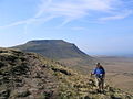
Ingleborough seen on the ascent of Simon Fell
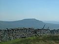
Ingleborough as seen from the summit of Whernside
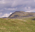
Ingleborough ascent


Outside links
- Ingleborough National Nature Reserve
- Three Peaks of Yorkshire
- Routes to climb Ingleborough
- Pictures of Ingleborough and the area on Geograph.co.uk
- Climb Ingleborough from Clapham
References
- ↑ Brook, A; Brook, D.; Griffith, J.; Long, M.H. (1991). Northern Caves Volume 2 The Three Peaks. Clapham, via Lancaster: Dalesman Publishing Company Ltd.. pp. 232–234. ISBN 1-85568-033-5.
- ↑ Waltham, Tony (2007). The Yorkshire Dales: Landscape and Geology. Malmesbury, Wiltshire: Crowood Press. ISBN 978-1-86126-972-0.