Hythe End
| Hythe End | |
| Buckinghamshire | |
|---|---|
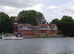
 Water extract plant buildings at Hythe End | |
| Location | |
| Location: | 51°26’38"N, 0°33’11"W |
| Data | |
| Post town: | Staines |
| Postcode: | TW19 |
| Dialling code: | 01784 |
| Local Government | |
| Council: | Windsor & Maidenhead |
Hythe End is a residential area to the south-east of Wraysbury in Buckinghamshire adjacent to the borders with Middlesex and Surrey. It is essentially a linear development on Staines Road, on the eastern bank of the River Thames close to Bell Weir Lock, with a large minority of properties adjoining the riverside.
Hythe End consists of several riverside homes, mainly on the Island, Hythe End. Gravel pits to the north containing water and reeds make up a Site of Special Scientific Interest. One of the major features of Hythe End is the river water extraction facility. This was built in 1910 by the Metropolitan Water Board to supply water from the River Thames to its works in Ashford Common via the Staines Aqueduct. This first feeds the King George VI Reservoir and continues eastwards, passing the water treatment works at Kempton Park, to provide some of the supply of the Kempton Park Reservoirs another water treatment works at Hampton.
Despite its small size, Hythe End has a junction (J13) on the M25 motorway.
| ("Wikimedia Commons" has material about Hythe End) |