Holme-on-Spalding-Moor
- Not to be confused with Holme on the Wolds
| Holme-on-Spalding-Moor | |
| Yorkshire East Riding | |
|---|---|
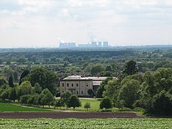 Holme Hall | |
| Location | |
| Grid reference: | SE805385 |
| Location: | 53°50’12"N, 0°46’42"W |
| Data | |
| Population: | 3,172 (2011) |
| Post town: | York |
| Postcode: | YO43 |
| Dialling code: | 01430 |
| Local Government | |
| Council: | East Riding of Yorkshire |
| Parliamentary constituency: |
Haltemprice and Howden |
Holme-on-Spalding-Moor (also known as Holme-upon-Spalding-Moor) is a large village in the East Riding of Yorkshire, standing about eight miles north-east of Howden and five miles south-west of Market Weighton. It is on the A163 road where it joins the A614 road.
The wider parish is formed by the village of Holme-on-Spalding-Moor and the hamlets of Bursea, Hasholme, Tollingham and Welhambridge. The 2011 census recorded a parish population of 3,172.
History
Holme-on-Spalding-Moor village is named for its location on the Spalding Moor.[1] The word Holme is Danish of origin and means island.[2][3]
Spalding Moor was a marsh, dominated by a single hill which consists of Keuper marl;[4] on the hill a small church was built in the 13th century which served as a landmark across the moor. The village was built on the holme west of the church, hence the name.[5]
Through the 17th and 18th centuries, the main occupation for people in the village was growing and dressing hemp. This gave rise to it sometimes been referred to as "Hemp-Holme".[6]
In July 1984, a late Iron Age logboat (750–390 BC), now known as the Hasholme Logboat, was discovered at Hasholme in the south-east of the parish.[7] The area was also noted for being a centre of Roman pottery. Numerous excavations have taken place since 1853, when several urns that had been found in the village were donated to the Yorkshire Philosophical Society.[8]
In 1823, Holme-on-Spalding-Moor was noting as being in the Harthill Wapentake, and the alternative village name of "Hemp Holme" is recorded – taken from the parish' former cultivation of hemp. A bed of gypsum was recorded in which ammonites were found. The church stands in an elevated position, on which is also sited a beacon, which gave its name of Holme Beacon to this contemporary part of Harthill Wapentake. The parish church and rectory was in the patronage of St John's College, Cambridge. There were two chapels, one Roman Catholic, the other, Methodist. Local landowners allotted land (cow-gates), for the personal use of their labourers. Population at the time was 1318. Occupations included twenty-three farmers and yeomen, three blacksmiths, two wheelwrights, three shoemakers, four shopkeepers, two coal dealers, two corn millers, a tailor, a butcher, a joiner, a bricklayer, and an ornamental plasterer. There were the landlords of The New Inn, The Hare and Hounds, The Sun, and The Blacksmiths' public houses. A carrier operated between the village and Market Weighton on Wednesdays, and Howden on Saturdays. Within the parish lived a banker, a steward to Lady Stourton [Mary Langdale], Charles Langdale at the Hall, a gentleman and a gentlewoman, a surgeon, and the parish rector. Baines records a traditional belief that a cell for two monks was founded at Welham Bridge on the edge of Spalding Moor by vavasours or constables. One monk was charged with guiding people over wasteland, the other praying for the safety of travellers.[9]
Holme-on-Spalding-Moor was served by Holme Moor railway station on the Selby to Driffield Line between 1848 and 1954.[10]
Holme Hall is a country house which was the seat of the Langdale barony. The hall is a Grade II* listed building.[11] It is now a Sue Ryder Care Home.
RAF
The moor was the site of a Royal Air Force station, RAF Holme-on-Spalding Moor, which was active during the Second World War and for several years thereafter as a bomber facility, being officially closed in 1954 and transferred to the United States Air Force, which moved out in 1957, and the field was sold to a private firm.[12]
The airfield continued in private hands until 1984, when its last tenant, British Aerospace, moved out. It was in a rather dilapidated condition by that time, and upon its closing several of the more notable buildings were destroyed and the runways removed. The hangars and several other buildings remain and are used by a variety of industrial and agricultural tenants, though all are in various states of disrepair.[13]
Churches
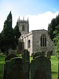
There are several churches, the largest being All Saints' Church which was mostly built in the 13th century, although a church is mentioned in the Domesday Book.[14]
All Saints is a Grade I listed building.[15]
- Church of England: All Saints
- Independent / evangelical: Christian Fellowship [16]
- Methodist church (formerly Primitive Methodist)
- Roman Catholic
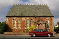
The Zion (ex-Wesleyan) Methodist Church closed in 1987[17] and is now a private house.
About the village
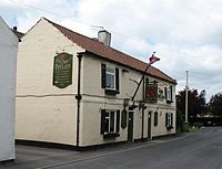
There are a few local convenience stores, a post office, a bakery and butchers, two takeaway outlets, a school and sports wear store, a pharmacy and doctors surgery, four public houses and a mobile library with internet access.
Nearby Howden, Goole and Market Weighton contain amenities including supermarkets and a number of chain-shops.
Sport
- Football: Holme Rovers, founded in 1922
Outside links
| ("Wikimedia Commons" has material about Holme-on-Spalding-Moor) |
- Holme-on-Spalding-Moor in the Domesday Book
- Information on Holme-on-Spalding-Moor from GENUKI
- RAF Holme On Spalding Moor Airfield
References
- ↑ [upon Spalding Moor Holme-on-Spalding-Moor] in the Domesday Book
- ↑ "Holme upon Spalding Moor :: Survey of English Place-Names". http://epns.nottingham.ac.uk/browse/East+Riding+of+Yorkshire/Holme+upon+Spalding+Moor/5328549ab47fc40a4d0004c5-Holme+upon+Spalding+Moor.
- ↑ Ekwall, Eilert, The Concise Oxford Dictionary of English Place-Names. Oxford, Oxford University Press, 4th edition, 1960. p. 246 ISBN 0198691033
- ↑ Cole, E. M. (1887). "On the physical geography and geology of the East Riding of Yorkshire". Proceedings of the Yorkshire Geological Society (Leeds: Yorkshire Geological Society) 9: 118. SSN 0044-0604.
- ↑ Bigland, John (1812). The beauties of England and Wales: or, Original delineations, topographical, historical, and descriptive, of each county Vol xvi, Yorkshire. London: Longman & Co. pp. 555–556. OCLC 701459620.
- ↑ Information on Holme-on-Spalding-Moor from GENUKI
- ↑ Millett, Martin; McGrail, Sean; Creighton, J. D.; Gregson, C. W.; Heal, S. V. E.; Hillam, J.; Holdridge, L.; Jordan, D. et al. (January 1987). "The Archaeology of the Hasholme Logboat". Archaeological Journal 144 (1): 69–155. doi:10.1080/00665983.1987.11021197.
- ↑ Halkon, Peter (2002). Wilson, P R; Price, J. eds. Aspects of industry in Roman Yorkshire and the North. Oxford: Oxbow. p. 21. ISBN 1842170783.
- ↑ Baines, Edward: 'History, Directory and Gazetteer of the County of York' (1823); pages 218, 219
- ↑ Butt, R. V. J. (1995). The Directory of Railway Stations: details every public and private passenger station, halt, platform and stopping place, past and present (1st ed.). Sparkford: Patrick Stephens Ltd. ISBN 978-1-85260-508-7. OCLC 60251199.
- ↑ National Heritage List 1083338: Holme Hall (Grade II* listing)
- ↑ Halpenny, Bruce Barrymore (1982). Action stations.. Wellingborough: Stephens. pp. 89–92. ISBN 0-85059-532-0.
- ↑ Delve, Ken (2006). Northern England : Co. Durham, Cumbria, Isle of Man, Lancashire, Merseyside, Manchester, Northumberland, Tyne & Wear, Yorkshire. Ramsbury: Crowood. p. 143. ISBN 1-86126-809-2.
- ↑ Farrer, William; Clay, Charles Travis, eds (2013). Early Yorkshire Charters. Volume 12 The Tison Fee.. Cambridge: Cambridge University Press. p. 67. ISBN 978-1-108-05827-8.
- ↑ National Heritage List 1025868: Church of All Saints (Grade I listing)
- ↑ "Holme Christian Fellowship". http://www.holmechristianfellowship.org/. Retrieved 4 August 2017.
- ↑ "Marriage Acts Notices". The London Gazette (51027): 10222. 12 August 1987. https://www.thegazette.co.uk/London/issue/51027/page/10222. Retrieved 4 August 2017.
- Gazetteer — A–Z of Towns Villages and Hamlets. East Riding of Yorkshire Council. 2006. p. 7.
