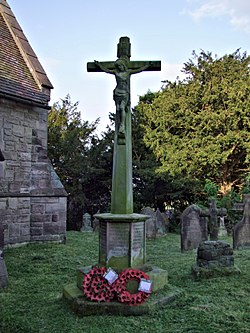
Hollington, Staffordshire
| Hollington | |
| Staffordshire | |
|---|---|
 Hollington War Memorial | |
| Location | |
| Grid reference: | SK055391 |
| Location: | 52°56’58"N, 1°55’8"W |
| Data | |
| Population: | 212 (2011) |
| Post town: | Stoke-on-Trent |
| Postcode: | ST10 |
| Local Government | |
| Council: | Staffordshire Moorlands |
| Parliamentary constituency: |
Staffordshire Moorlands |
Hollington is a village in Staffordshire, in the hills in the north-east of the county known as the Staffordshire Moorlands, four miles from the River Dove which marks the Derbyshire border (and by coincidence a further six miles due east is a namesake village, Hollington, Derbyshire).
The 2011 census recorded a village population of 212.
The village has a church and two pubs, The Star and The Raddle. There is a village hall, though the village shop closed in 1992.
The nearest town to Hollington is the little market town of Uttoxeter just under five miles to the south-east, or Cheadle to the north-west.
The village stands at the end of a ridge extending to the south with deep valleys to the north, and it enjoys beautiful views. A hamlet, Great Gate, stands a mile to the north-east. An ancient Roman road runs through the village, from through Rocester and Derby (Roman Derventio) in the east, the Derbyshire section being called Long Lane, and onwards to the north west through the village of Upper Tean.
The quarries at Hollington produce the notable pink-red and white "Hollington stone" (a type of sandstone[1]) which has been used for centuries in the construction of churches and stately homes.[2] It was used for the construction of the new Coventry Cathedral in the 1950s.
Outside links
| ("Wikimedia Commons" has material about Hollington, Staffordshire) |