Hingston Down
From Wikishire
Revision as of 00:21, 13 February 2015 by RB (Talk | contribs) (Created page with "{{Infobox hill |name=Hingston Down |county=Cornwall |picture=The Northern Slope of Hingston Down - geograph.org.uk - 317830.jpg |picture caption=The Northern Slope of Hingston...")
| Hingston Down | |
| Cornwall | |
|---|---|
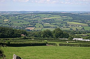
 The Northern Slope of Hingston Down | |
| 50°31’16"N, 4°14’50"W | |
Hingston Down is a hill in eastern Cornwall, not far from Gunnislake.
History
The hill is usually accepted as the place mentioned in an entry in the Anglo-Saxon Chronicle for 835 (corrected by scholars to 838) which says that Egbert]] king of the West Saxons defeated an army of Vikings and Cornish at the Battle of Hingston Down. The name of the hill is Old English; Hengestdun, meaning 'Stallion Hill'.
Geology
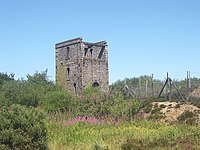
The Hingston Down Consols mine on the hill is the type locality for the mineral Arthurite,[1] which was discovered here.[2] There is also a quarry on the hill,[3] which forms the Hingston Down Quarry & Consols SSSI (Site of Special Scientific Interest), noted for its mineralisation.[4]
References
- ↑ Hingston Down Consols, Gunnislake Area, Callington District, Cornwall, England, UK
- ↑ Embrey, P. G.; Symes, R. F. (1987). "The mines and mining". Minerals of Cornwall and Devon. London: British Museum (Natural History). p. 58. ISBN 0-565-00989-3.
- ↑ Hingston Down Quarry, Gunnislake Area, Callington District, Cornwall, England, UK
- ↑ "Hingston Down Quarry & Consols". Natural England. 1995. http://www.sssi.naturalengland.org.uk/citation/citation_photo/2000098.pdf. Retrieved 1 November 2011.
