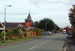
Higher Kinnerton
From Wikishire
Revision as of 14:23, 4 November 2014 by Owain (Talk | contribs) (Created page with "{{Infobox town |name=Higher Kinnerton |county=Flintshire |picture=Main Road, Higher Kinnerton - geograph.org.uk - 588080.jpg |picture caption=Main Road, Higher Kinnerton |os g...")
| Higher Kinnerton | |
| Flintshire | |
|---|---|
 Main Road, Higher Kinnerton | |
| Location | |
| Grid reference: | SJ328613 |
| Location: | 53°8’43"N, 3°0’18"W |
| Data | |
| Post town: | Chester |
| Postcode: | CH4 |
| Dialling code: | 01244 |
| Local Government | |
| Council: | Flintshire |
| Parliamentary constituency: |
Alyn and Deeside |
Higher Kinnerton is a small residential village in Flintshire, very close to the border with Cheshire. Its sister village, Lower Kinnerton lies on the other side of the border.
Education
The village has a primary school, Derwen School. The local secondary schools are Castell Alun High School in Hope and Hawarden High School in Hawarden.
Amenities
The village has a post office, a shop, and two public houses, The Swan and The Royal Oak. The parish church is All Saints, which is actually in the parish of Dodleston in Cheshire. There is a scout group called 1st Kinnerton Scouts. There is also a village hall which hosts various community clubs & events.
The celebrity cook Nigella Lawson spent some of her childhood here.