Hardingham
From Wikishire
Revision as of 14:19, 21 April 2017 by Owain (Talk | contribs) (Created page with "{{Infobox town |county=Norfolk |latitude=52.59469 |longitude=1.01667 |os grid ref=TG044039 |population=267 |census year=201)<ref>{{cite web|url=http://www.neighbourhood.statis...")
| Hardingham | |
| Norfolk | |
|---|---|
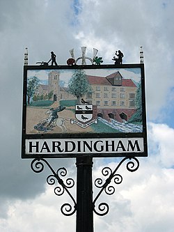
 Hardingham Village sign | |
| Location | |
| Grid reference: | TG044039 |
| Location: | 52°35’41"N, 1°1’0"E |
| Data | |
| Population: | 267 (201)[1]) |
| Post town: | Norwich |
| Postcode: | NR9 |
| Local Government | |
| Council: | Breckland |
| Website: | hardingham-pc.org.uk |
Hardingham is a parish in Norfolk. It covers an area of nearly four square miles and had a population of 274 in 110 households at the 2001 census,[2] decreasing to a population of 267 in 107 households at the 2011 Census. The parish includes the hamlet of Danemoor Green about one mile north-east of the main village.
The village is most notable for Hardingham railway station, a stop on the Mid-Norfolk Railway. It is a few miles away from the town of Wymondham, and roughly fifteen miles from Norwich.
Notes
| ("Wikimedia Commons" has material about Hardingham) |
- ↑ "Civil Parish population 2011". Neighbourhood Statistics. Office for National Statistics. http://www.neighbourhood.statistics.gov.uk/dissemination/LeadKeyFigures.do?a=7&b=11124218&c=Hardingham&d=16&e=62&g=6448241&i=1001x1003x1032x1004&o=362&m=0&r=1&s=1470419828307&enc=1. Retrieved 5 August 2016.
- ↑ Census population and household counts for unparished urban areas and all parishes. Office for National Statistics & Norfolk County Council (2001). Retrieved 20 June 2009.