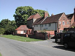
Halloughton
| Halloughton | |
| Nottinghamshire | |
|---|---|

| |
| Location | |
| Grid reference: | SK688516 |
| Location: | 53°3’25"N, 0°58’26"W |
| Data | |
| Post town: | Southwell |
| Postcode: | NG25 |
| Dialling code: | 0115 |
| Local Government | |
| Council: | Newark and Sherwood |
| Parliamentary constituency: |
Newark |
Halloughton is a village in Nottinghamshire, nine miles west of Newark-on-Trent. Most of the property in the village was owned by the Church Commissioners until 1952.
The village is to be found to the north of Halloughton Dumble, a wooded valley. It is some three miles from the River Trent at Bleasby, on the main A60 road, with county town, Nottingham eleven miles away, and the county's ecclesiastical capital, Southwell, three miles distant.
About the village
The parish church, St James, was rebuilt in 1879–1882.
Halloughton Manor House is a 13th-century prebendal house of the college of Southwell. Its mediæval tower house is now incorporated into a farmhouse of the late 18th century.[1]
Most of the farms and properties in the parish were owned by the Church Commissioners until 1952, when they were sold to their sitting tenants.[2]
Outside links
| ("Wikimedia Commons" has material about Halloughton) |
References
- ↑ Nikolaus Pevsner: The Buildings of England: Nottinghamshire, 1951; 1979 Penguin Books ISBN 978-0-300-09636-1
- ↑ Southwell & Nottingham Church History Project