Difference between revisions of "Haddon"
From Wikishire
(Created page with '{{Infobox town |name=Haddon |county=Huntingdonshire |picture=St Mary Haddon Church - geograph.org.uk - 309533.jpg |os grid ref=TL142923 |latitude=52.517 |longitude=-0.316 |post …') |
m |
||
| Line 16: | Line 16: | ||
Haddon lies in the midst of the fields. It consists of a few houses and a small early English church, St Mary's, which is mostly noted for its disproportionately large Norman chancel arch. | Haddon lies in the midst of the fields. It consists of a few houses and a small early English church, St Mary's, which is mostly noted for its disproportionately large Norman chancel arch. | ||
| − | The village is close to [[Chesterton, Huntingdonshire|Chesterton]], west of [[Yaxley, | + | The village is close to [[Chesterton, Huntingdonshire|Chesterton]], west of [[Yaxley, Huntingdonshire|Yaxley]]. |
==Outside links== | ==Outside links== | ||
Latest revision as of 20:20, 16 April 2012
| Haddon | |
| Huntingdonshire | |
|---|---|

| |
| Location | |
| Grid reference: | TL142923 |
| Location: | 52°31’1"N, 0°18’58"W |
| Data | |
| Post town: | Peterborough |
| Postcode: | PE7 |
| Local Government | |
| Council: | Huntingdonshire |
| Parliamentary constituency: |
North West Cambridgeshire |
Haddon in Huntingdonshire is a remote village in farming country not many miles west of Peterborough, but separated by the fierce corridor of the A1M and by the farmland about the village.
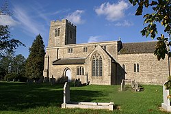
Haddon lies in the midst of the fields. It consists of a few houses and a small early English church, St Mary's, which is mostly noted for its disproportionately large Norman chancel arch.
The village is close to Chesterton, west of Yaxley.
Outside links
| ("Wikimedia Commons" has material about Haddon) |
