Gumfreston
From Wikishire
Revision as of 13:18, 7 December 2016 by Owain (Talk | contribs) (Created page with "{{infobox town |county=Pembroke |picture=Gumfreston Church - geograph.org.uk - 47692.jpg |picture caption=Parish church of St Lawrence |latitude=51.678 |longitude=-4.736 |popu...")
| Gumfreston | |
| Pembrokeshire | |
|---|---|
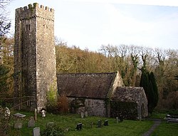
 Parish church of St Lawrence | |
| Location | |
| Grid reference: | SN109012 |
| Location: | 51°40’41"N, 4°44’10"W |
| Data | |
| Population: | 103 |
| Post town: | Tenby |
| Postcode: | SA70 |
| Local Government | |
| Council: | Pembrokeshire |
Gumfreston is an ancient parish and small village in Pembrokeshire, located a mile from St Florence and two miles from Tenby. The B4318 is the main road that passes through Gumfreston.
It has a small church with a tall tower[1] and a few houses, including Glebe farm.
References
- ↑ "GENUKI: Gumfreston". http://www.genuki.org.uk/files/wal/PEM/Gumfreston/index.html. Retrieved 6 March 2016.
Outside links
| ("Wikimedia Commons" has material about Gumfreston) |