Great Torrington
| Great Torrington | |
| Devon | |
|---|---|
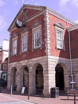
 The old Town Hall, Great Torrington | |
| Location | |
| Grid reference: | SS4919 |
| Location: | 50°57’2"N, 4°9’4"W |
| Data | |
| Post town: | Torrington |
| Postcode: | EX38 |
| Dialling code: | 01805 |
| Local Government | |
| Council: | Torridge |
| Parliamentary constituency: |
Torridge and West Devon |
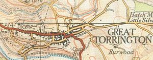
Great Torrington (often abbreviated to Torrington) is a small market town in the north of Devon. It is built ona hill, running from the high slopes down to the banks of the River Torridge below. The centre of the town commands spectacular views form the hill slopes, while the lower-lying parts down by the quay are prone to occasional flooding.
Nearby are the villages of Little Torrington and Black Torrington.
Torrington is marketed as lying in the heart of Tarka Country; the landscape captured by Henry Williamson in his novel Tarka the Otter in 1927.
Great Torrington is reckoned to have the most active volunteering community in the United Kingdom.[1]
Contents
Parish church
The parish church is St Michael's. Its grounds include a mound said to contain the remains of 60 Civil War Royalist soldiers, which is a grim reminder of the battle of Torrington in 1646.
Railway and the Tarka Trail
The branch line to Bideford was extended to Great Torrington in July 1872, by the London and South Western Railway, which built a railway station and locomotive depot in the town. The locomotive depot was closed in 1959 and the line was closed to passenger traffic as part of the Beeching Axe. It was closed to goods traffic in 1984. At the site of the old station there is currently a pub named The Puffing Billy, a cycle hire shop and an old carriage, an old wagon, a brake van, and a small diesel engine. A few small sections of track remain, but most has been removed and replaced with a combined foot and cycle path as part of the Tarka Trail. The Tarka Trail continues to Bideford, Barnstaple and on to Braunton in one direction and to Meeth in the other, making 32 miles of traffic-free trail.
History
There were Iron Age and mediæval castles and forts in Torrington, located on the Castle Hill.
The town had strategic significance in the Civil War, commending a major route from north to the south of Devon and thus the whole north of the county and the approach to Cornwall. At the Battle of Torrington in 1646, the Parliamentarians, led by Sir Thomas Fairfax, swept into the town and defeated Lord Hopton's forces. This marked the end of Royalist resistance in the West Country. Today the town is recognised as an important heritage centre for the history of the 17th century, and its people can often be seen dressed in costume for historical re-enactments, festivals and celebrations. An interactive Civil War Experience, "Torrington 1646", marks the town's historically important role.
Mayfair
Mayfair is an annual folk festival believed to date back to 1554 in which the children of Torrington dance around a maypole set up in the town square. The event takes place on the first Thursday in May.
The junior school children elect a May Queen and she is crowned in the town square after a procession with attendants. There is then Maypole dancing after which all go off to the fair.
Torrington Common
Torrington Common is an area of common land which surrounds the town on all but the eastern side. The common is administered by a body called "The Commons Conservators". The Common covers 365 acres and has over 20 miles of public rights of way. The landscape features a variety of habitats and a rich collection of flora and fauna.
History of the common
An "area of waste called the Common" was donated to the town in 1194 by Baron FitzRobert of Torrington. In 1889 the rights to this land were transferred by an Act of Parliament to an elected Committee of Conservators.
Since 2 October 1889 the Conservators have met regularly to fulfil their remit to manage the land. Early activity was mainly concerned with control over the grazing and quarrying of the common, but since 1980 grazing has stopped and instead various techniques have taken its place to prevent the common from reverting to scrub and woodland.There has also been development on the commons which many locals oppose and believe is not legitimate.
Features of the common
- Taddiport Bridge and Rothern Bridge: Prior to the opening of the Town Mills Bridge, these were the only local crossings of the River Torridge.
- Rolle Road: This is the site of the Rolle Canal which opened in 1827 to help transport clay, lime and other commodities between the boats on the tidal river at Landcross and the lime kilns, clay pits and farms around Torrington. It ran through common land, but was closed in 1871. Later, it was filled in to create a toll road across the Common.
- Waterloo Monument: A stone obelisk erected in 1818 by "the ladies of Great Torrington" to commemorate the Battle of Waterloo.
Sights of the town
Other attractions in Great Torrington include:
- Dartington Crystal, A factory, visitors centre, glass shop and restaurant of world famous Dartington Crystal – the biggest employer in the town and now the only working glass factory left in the United Kingdom.
- Rosemoor Garden, a collection of internationally recognised gardens, woodlands and parkland owned by the Royal Horticultural Society.
- A Victorian pannier market with a glass roof, restored in the early 2000s.
- The Plough arts centre, a small theatre, cinema and gallery.
- Torrington 1646 Visitor Centre celebrates the town's role in the Civil War through exhibitions and talks by guides dressed in period costume and using the language of the age.
- Great Torrington has a good selection of pubs selling good food and a selection of real ales. These include The Torridge Inn, The Black Horse, Torrington Arms, Cavalier, Globe and Royal Exchange.
Torrington has a small local brewery called Clearwater Brewery with its popular "Cavalier" and "1646" brands.
Employment
Torrington has long been a factory town. In the nineteenth century it was a centre of the glove making industry. The major employer today is Dartington Crystal, but the shops in the town centre also provide a source of employment.
Most of the shops are locally owned but some national chains have edged in, including branches of several banks. Large factories have deserted the town in recent years including the meat factory after a fire, and the milk factory which also caught fire has moved its production elsewhere. Various converted and purpose built care homes in the town also provide a significant source of employment.
Media
- Newspapers:
- The North Devon Journal based in Barnstaple.
- The North Devon Gazette every week.
- The Crier (monthly community newsletter)
Big Society
Sport
- Football: Torrington FC
There are also the local rugby, golf, netball, bowling, tennis and swimming teams. Torrington Golf Course is 1.5 miles from the town centre and has 9 holes.
Outside links
References
- ↑ Edwards, Goodwin and Woods (2003), Citizenship, community and participation in small towns: a case study of regeneration partnerships, in Imrie and Raco (eds), Urban Renaissance?: New Labour, community and urban policy, Policy Press, Bristol
