Great Shunner Fell
| Great Shunner Fell | |||
| Yorkshire | |||
|---|---|---|---|
 Great Shunner Fell from the north-east | |||
| Range: | Yorkshire Dales | ||
| Summit: | 2,349 feet SD848972 54°22’12"N, 2°14’8"W | ||
Great Shunner Fell is one of the highest of the fells within the Yorkshire Dales, and the highest overlooking Wensleydale,[1] rising to a summit 2,349 feet above sea level, on the ridge which separates Wensleydale from Swaledale. In clear weather the summit affords views of Wensleydale to the south, Ribblesdale to the south-west and Swaledale to the north, as well as views into Westmorland and County Durham beyond the River Tees.
The Pennine Way passes over the summit of Great Shunner Fell, on the way from Hawes to Keld. The popularity of this route had eroded vegetation from a strip 75 yards wide across the moor, which has been alleviated since 1996 by the construction of a path made of flagstones.[2]
The summit holds a cross-shaped windbreak of which the triangulation pillar has been built into the northern arm.
Great Sleddale Beck, which becomes the River Swale after its confluence with Birkdale Beck has its sources on the northern slopes of Great Shunner Fell, while the southern slopes drain into the River Ure and Wensleydale.
The dominating rock type in the area is limestone, but millstone grit forms outcrops extensively on Great Shunner Fell, and coal seams have also been worked on its slopes.[3]
Great Shunner Fell is the most southerly remaining outpost in Great Britain for the yellow marsh saxifrage, Saxifraga hirculus.[4]
Pictures
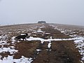
The last few yards to the summit
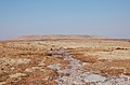
The summit plateau of Great Shunner Fell viewed from the south


References
- ↑ "Cotterdale and Great Shunner Fell". Dalesman.co.uk. December 2003. http://www.dalesman.co.uk/walks/cotterdale.htm.
- ↑ "Pennine Way". Yorkshire Dales National Park Authority. 2006. http://www.yorkshiredales.org.uk/ranger_service_pennine_way.
- ↑ "Wensleydale character areas". Yorkshire Dales National Park Authority. 2006. http://www.yorkshiredales.org.uk/wensleydale_character_areas.
- ↑ "Yellow marsh saxifrage Saxifaga hirculus species action plan". Yorkshire Dales National Park Authority. http://www.yorkshiredales.org.uk/yellow_marsh_saxifrage_saxifaga_hirculus_sap.pdf.