Difference between revisions of "Great Rhos"
From Wikishire
(Created page with '{{Infobox hill |name=Great Rhos |welsh=Rhos Fawr |county=Radnorshire |range=Cambrian Mountains |picture=Great Rhos.jpg |picture caption=Great Rhos summit trig point |height=2,16…') |
|||
| Line 8: | Line 8: | ||
|height=2,166 feet | |height=2,166 feet | ||
|os grid ref=SO18226390 | |os grid ref=SO18226390 | ||
| + | |latitude=52.2671 | ||
| + | |longitude=-3.1998 | ||
}} | }} | ||
'''Great Rhos''' is a mountain in [[Radnorshire]]; the highest point of that county. It is within the [[Radnor Forest]], not in woodland (the Forest was such in the mediæval sense of a game reserve, though wooded on lower slopes). | '''Great Rhos''' is a mountain in [[Radnorshire]]; the highest point of that county. It is within the [[Radnor Forest]], not in woodland (the Forest was such in the mediæval sense of a game reserve, though wooded on lower slopes). | ||
| Line 13: | Line 15: | ||
Great Rhos rises as a great mass of rock in the forest, its top a vast, flat plateau of boggy heather moorland. | Great Rhos rises as a great mass of rock in the forest, its top a vast, flat plateau of boggy heather moorland. | ||
| − | |||
The slopes drop away steeply on each side of the broad plateau. To the east it drops away into Harley Dingle, the steep, forbidden valley used as a shooting range and testing ground for ammunition and where the unwary trespasser may find the odd live shell underfoot. | The slopes drop away steeply on each side of the broad plateau. To the east it drops away into Harley Dingle, the steep, forbidden valley used as a shooting range and testing ground for ammunition and where the unwary trespasser may find the odd live shell underfoot. | ||
| + | |||
| + | ==Gallery== | ||
| + | <gallery> | ||
| + | File:Head of Cwm Merwys - geograph.org.uk - 840225.jpg||Cwm Merwys on the northern slope | ||
| + | File:Harley Dingle - geograph.org.uk - 27471.jpg|Harley Dingle | ||
| + | </gallery> | ||
==Outside links== | ==Outside links== | ||
| − | |||
*[http://www.geograph.org.uk/search.php?i=2798081 www.geograph.co.uk : photos of Great Rhos and surrounding area] | *[http://www.geograph.org.uk/search.php?i=2798081 www.geograph.co.uk : photos of Great Rhos and surrounding area] | ||
| − | |||
| − | |||
| − | |||
[[Category:County tops]] | [[Category:County tops]] | ||
Latest revision as of 19:54, 6 September 2017
| Great Rhos | |||
| Radnorshire | |||
|---|---|---|---|
 Great Rhos summit trig point | |||
| Range: | Cambrian Mountains | ||
| Summit: | 2,166 feet SO18226390 52°16’2"N, 3°11’59"W | ||
Great Rhos is a mountain in Radnorshire; the highest point of that county. It is within the Radnor Forest, not in woodland (the Forest was such in the mediæval sense of a game reserve, though wooded on lower slopes).
Great Rhos rises as a great mass of rock in the forest, its top a vast, flat plateau of boggy heather moorland.
The slopes drop away steeply on each side of the broad plateau. To the east it drops away into Harley Dingle, the steep, forbidden valley used as a shooting range and testing ground for ammunition and where the unwary trespasser may find the odd live shell underfoot.
Gallery
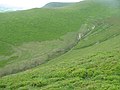
|Cwm Merwys on the northern slope
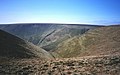
Harley Dingle

