Grassholme
| Grassholme | |
| Yorkshire North Riding | |
|---|---|
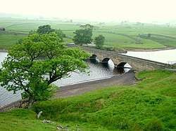
 Bridge at the head of Grassholme Reservoir | |
| Location | |
| Grid reference: | NY984207 |
| Location: | 54°34’55"N, 2°1’34"W |
| Data | |
| Local Government | |
| Council: | Durham |
Grassholme is a village in the very north of the North Riding of Yorkshire. It is in Lunedale, in the stretch of that little dale which has been harnessed by the hand of man: Grassholme sits below the dam of the Selset Reservoir and above the Grassholme Reservoir.
The Grassholme Reservoir is the earlier of the two, built in the later nineteenth century, while the Selset Reservoir if of the 1950s.[1] The creation of the Victorian reservoir at Grassholme submerged amongst other things a stone packhorse bridge, which re-emerges from the depths when the water is very low.[1] The bridge of today carrying the lane across over the head of the reservoir is somewhat more recent.
To the north is Teesdale, the county's northern border. The nearest town is across that border; Middleton-in-Teesdale.
Outside links
| ("Wikimedia Commons" has material about Grassholme) |