Goldington
| Goldington | |
| Bedfordshire | |
|---|---|
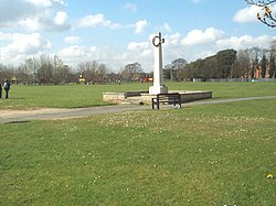
 Goldington Green and war memorial | |
| Location | |
| Grid reference: | TL076510 |
| Location: | 52°8’49"N, 0°25’39"W |
| Data | |
| Population: | 8,603 (2011) |
| Post town: | Bedford |
| Postcode: | MK41 |
| Dialling code: | 01234 |
| Local Government | |
| Council: | Bedford |
| Parliamentary constituency: |
Bedford |
Goldington is a Bedfordshire village which has become a suburb of the county town, Bedford. The boundaries of Goldington are today obscured by the growth of housing, but may be reckoned approximately at Norse Road and the cemetery to the north and east, Goldington Road to the south, with Church Lane and Haylands Way to the west. The northern part of the area is sometimes known as Elms Farm.
Churches
- Church of England:
- Roman Catholic: Holy Cross
St Mary the Virgin has a combination of 15th and 20th century architecture. It has a 14th-century font, and 16th century brasses.
Community facilities
Goldington Community Centre is on Church Lane. The Green is the area's largest open space, and is situated on Church Lane and Goldington Road. Goldington Bury cricket ground is situated next to Goldington Green. Goldington Bury is the home ground of Bedford Cricket Club.
History
Goldington was a village which grew up along the old A428 road between Bedford and Cambridge. The parish church, St Mary's, has parish registers going back to 1559.
In August 1645 Major Walter Baskerville a Royalist cavalry officer was killed in a skirmish in Goldington.
Goldington Hall (a small mansion) was built in the 1650s. The Hall was rebuilt in 1874.[1]
In 1934 the civil parish was divided as Bedford expanded; the southern part of the parish was swallowed by the Borough of Bedford, and the rest parcelled out to the parishes of Ravensden and Renhold. The borough later expanded further north to swallow all of Goldington. This expansion included the development of the Elms Farm estate and the Church Lane shopping parade. The Poppyfields estate was developed in the area in the 1990s.
In the 21st century The Spires and the Saxon Grange housing estates have been constructed on the northern boundary of Goldington.
After many years as a pub, the old Goldington Hall became semi-derelict and was the scene of a small fire in 2008.[1] It is now a private residence.
Goldington Castle, a motte-and-bailey castle, was built at some time after 1066. It stands not within Goldington itself but by neighbouring Newnham.
Economy
There are two shopping parades in Goldington at which most shops and services are to be found, on Church Lane and on Queens Drive.
There are still a few shops and pubs along the old village High Street (Goldington Road).
To the eastern side of Goldington is the Elms & Viking Industrial estate. This large business park (between Goldington Road and Norse Road) houses many firms and the East of England Ambulance Service.