Glen Lochay
Feb1998.jpg)
Glen Lochay (Gaelic: Gleann Lòchaidh) in Perthshire is the valley through which the River Lochay runs eastward towards Loch Tay, joining the River Dochart at Killin. Glen Lochay is about 20 miles long, running from a point north of Crianlarich to Loch Tay.
A road runs up the glen as far as Kenknock Farm, but there is no vehicular access beyond this point. A track leads further up the glen past cottages at Badour, then Batavaime Farm), the last occupied building in Glen Lochay. The ruins of cottages can be seen higher up the glen, but these were vacated long ago.
The route of a seven-mile walk through this "delightful and remote glen" is documented.[1]
There is an extensive local hydroelectric network throughout this area, much of which is buried under the ground and goes largely unseen, but some pipelines are visible crossing the glen.
Pictures
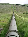
Water pipe across the glen
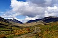
Glen Lochay looking west
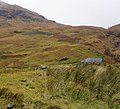
Batavaime farm
Jul2005.jpg)
May1996.jpg)
Nov2004.jpg)
Outside links
References
- ↑ Colin Hogarth (2004). "Looking for Lochay". walkscotland.com. http://www.walkscotland.com/route73.htm. Retrieved 2007-01-20.