Gilberdyke
| Gilberdyke | |
| Yorkshire East Riding | |
|---|---|
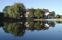
 Jubiliee Pond, Gilberdyke | |
| Location | |
| Grid reference: | SE834291 |
| Location: | 53°45’7"N, 0°44’10"W |
| Data | |
| Population: | 3,430 (2011) |
| Post town: | Brough |
| Postcode: | HU15 |
| Dialling code: | 01430 |
| Local Government | |
| Council: | East Riding of Yorkshire |
| Parliamentary constituency: |
Haltemprice and Howden |
Gilberdyke is a village in the East Riding of Yorkshire, twenty miles south-east of York and nineteen miles west of Kingston upon Hull. The closest town is Howden, five miles away. The village is on the B1230 road, mile south of the M62 motorway.
The wider civil parish enfolds also such hamlets as Bennetland, Hive, Sandholme and Scalby. The 2011 census recorded this parish with a population of 3,430.
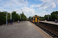
The village is served by Gilberdyke railway station with trains operating between Scarborough and Bridlington via Hull to Doncaster and Sheffield.
History
The village was recorded as simply 'Dyc' in 1234 and 'Dyke' in 1336; 'Gilberdyke' was first mentioned in 1349, and 'Gilbertdike' in 1376. Who 'Gilbert' refers to is unknown.[1]
In 1823, Gilberdyke was in the parish of Eastrington, the Wapentake of Holderness, and the Liberty of St Peter. Population, including the settlements of Hive and Sandholme, was 640. Occupations at the time included four farmers, two blacksmiths, two carpenters, a shoemaker, a corn miller, a constable, a schoolmaster, an overseer, and the licensed victualler of The Cross Keys public house.[2]
Outside links
| ("Wikimedia Commons" has material about Gilberdyke) |
References
- ↑ Ekwall, Eilert, The Concise Oxford Dictionary of English Place-Names. Oxford, Oxford University Press, 4th edition, 1960. p. 195 ISBN 0198691033
- ↑ Baines, Edward: 'History, Directory and Gazetteer of the County of York' (1823); page 210
- Gazetteer – A–Z of Towns Villages and Hamlets. East Riding of Yorkshire Council. 2006. p. 6.


