Garliestown
| Garlieston | |
| Wigtownshire | |
|---|---|
 Garlieston Harbour | |
| Location | |
| Grid reference: | NX485465 |
| Location: | 54°47’26"N, 4°21’28"W |
| Data | |
| Post town: | Newton Stewart |
| Postcode: | DG8 |
| Dialling code: | 01988 |
| Local Government | |
| Council: | Dumfries and Galloway |
| Parliamentary constituency: |
Dumfries and Galloway |
Garlieston is a small, planned coastal village in Wigtownshire. It was founded in the mid 18th century by Lord Garlies, later 6th Earl of Galloway.
Location & History
The village stands 5 miles northwest of Whithorn and a few miles north of Cruggleton Castle, which was abandoned in the 17th century. The seat of the Earls of Galloway, Galloway House, is situated on the edge of the village, with the settlement being planned along Georgian lines. The port became an important import point for goods being brought into the Machars throughout the 19th and early 20th centuries. In 1876 the Wigtownshire Railway was extended to the village and goods flowed regularly through the port, with the maritime industries of shipbuilding and associated activities taking place in the village.
Second World War
During the Second World War the village became part of the secret Mulberry Harbour project. The profile of the beach and sea bed at Garlieston was similar to that of the proposed harbour points in Normandy and that, coupled with the remote nature of the locality, led to Garlieston and the surrounding area being selected as the development region for the harbours. Prototypes of the harbours were constructed at Conwy in Caernarfonshire and then transported and positioned in Wigtown Bay, where they were tested and modified through 1943 and 1944. A fixed pierhead from the harbours could be seen in Cruggleton (or Rigg) Bay until it was destroyed by a storm on Sunday 12 March 2006.
Currently
Today the village is in general a quiet sleepy place, with much of the local industry and port activity having ceased over the past 50 years. A bowling green sits on the waterfront and the village caravan site attracts tourists, with the harbour providing berthing facilities for those who are touring by boat.
Annually in the early summer there is a ferry trip from Garlieston harbour to the Isle of Man.
There is currently something of a surge in development. A long-abandoned old granary near the harbour has been demolished and is being replaced with blocks of flats, while a new estate of 24 luxury houses is proposed to the garage at the approach to the village. Plans are underway for two new houses on the site of a former garage beyond the southern edge of the village.
These changes may be connected with the increasing popularity of Wigtownshire as a second home and retirement location, especially for couples from Lancashire.
Pictures
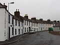
Garlieston Main Street
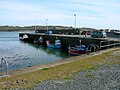
Garlieston harbour
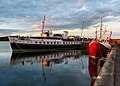
Garlieston Bay and Harbour


Outside links
- Combined-ops Information on the Mulberry Harbours & the role Garlieston played in their development