Difference between revisions of "Galley Common"
From Wikishire
(bracket fix) |
(Add) |
||
| (2 intermediate revisions by the same user not shown) | |||
| Line 4: | Line 4: | ||
|picture=Galley_Common_from_hill.jpg | |picture=Galley_Common_from_hill.jpg | ||
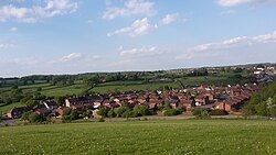
|picture caption=Galley Common from hill | |picture caption=Galley Common from hill | ||
| − | |os grid ref= | + | |os grid ref=SP 3182 9187 |
|latitude=52.5245 | |latitude=52.5245 | ||
|longitude=-1.5392 | |longitude=-1.5392 | ||
| − | |population= | + | |population=8233 |
| − | |census year= | + | |census year=2011 |
|post town=Nuneaton | |post town=Nuneaton | ||
|postcode=CV10 | |postcode=CV10 | ||
| − | |dialling code= | + | |dialling code=024 |
| − | |LG district= | + | |LG district=Nuneaton & Bedworth |
|constituency=Nuneaton | |constituency=Nuneaton | ||
}} | }} | ||
| − | '''Galley Common''' is a village near [[Nuneaton]], [[Warwickshire]].<ref>[https://getoutside.ordnancesurvey.co.uk/local/galley-common-nuneaton-and-bedworth Ordnance Survey]</ref> | + | '''Galley Common''' is a village near [[Nuneaton]], [[Warwickshire]].<ref>[https://getoutside.ordnancesurvey.co.uk/local/galley-common-nuneaton-and-bedworth Ordnance Survey]</ref> It had a population of 8,233 in 2011. It lies near the villages of [[Hartshill]] and [[Ansley]]. It was previously a coal mining village, with a hill overlooking it left behind from coal mining, although this hill has been flattened significantly to prevent it from blocking out sunlight from parts of the village. |
| − | + | ||
| − | [[ | + | |
==References== | ==References== | ||
{{reflist}} | {{reflist}} | ||
| + | |||
| + | {{stub}} | ||
| + | [[Category:Towns and villages in Warwickshire]] | ||
Latest revision as of 15:17, 9 October 2019
| Galley Common | |
| Warwickshire | |
|---|---|
 Galley Common from hill | |
| Location | |
| Grid reference: | 3182&y=2 9187&z=120 SP 3182 9187 |
| Location: | 52°31’28"N, 1°32’21"W |
| Data | |
| Population: | 8,233 (2011) |
| Post town: | Nuneaton |
| Postcode: | CV10 |
| Dialling code: | 024 |
| Local Government | |
| Council: | Nuneaton & Bedworth |
| Parliamentary constituency: |
Nuneaton |
Galley Common is a village near Nuneaton, Warwickshire.[1] It had a population of 8,233 in 2011. It lies near the villages of Hartshill and Ansley. It was previously a coal mining village, with a hill overlooking it left behind from coal mining, although this hill has been flattened significantly to prevent it from blocking out sunlight from parts of the village.