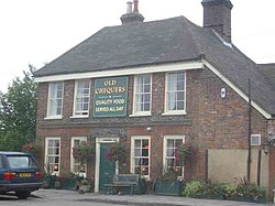
Gaddesden Row
From Wikishire
| Gaddesden Row | |
| Hertfordshire | |
|---|---|

| |
| Location | |
| Grid reference: | TL055125 |
| Location: | 51°48’4"N, 0°28’17"W |
| Data | |
| Postcode: | HP2 |
| Local Government | |
| Council: | Dacorum |
Gaddesden Row is a hamlet in Hertfordshire strung out along a long lane in a valley in the Chilterns, close to the Bedfordshire border. The hamlet is named from the lane, named Gaddesden Row, and is part of the parish of Great Gaddesden, which latter village lies two miles southwest.
Gaddesden Row has its own school and a Methodist church, which was founded as a village mission-room. At Water End, shaded by large trees and close to a broad pool of the river, are clustered a few old redbrick red-tiled cottages.