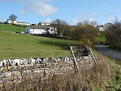
Forest-in-Teesdale
From Wikishire
| Forest-in-Teesdale | |
| County Durham | |
|---|---|
 Forest-in-Teesdale | |
| Location | |
| Grid reference: | NY867298 |
| Location: | 54°39’50"N, 2°12’22"W |
| Data | |
| Post town: | Barnard Castle |
| Postcode: | DL12 |
| Dialling code: | 01833 |
| Local Government | |
| Council: | County Durham |
| Parliamentary constituency: |
Bishop Auckland |
Forest-in-Teesdale is a village in County Durham, in upper Teesdale, on the north side of the Tees which marks the border with Yorkshire to the south.
Close by the village, downstream on the Tees is a famous, mighty waterfall, High Force, which brings vistors to the village. Higher up the river is another, Cauldron Snout, and further south is Yorkshire's county top, Mickle Fell.
The village is on the road up Teesdale, between Newbiggin and Langdon Beck.
Forest-in-Teesdale holds the United Kingdom record for the greatest snow depth in an inhabited area with 83 inches (just short of 7 feet) which occurred on 14 March 1947.[1]
Outside links
| ("Wikimedia Commons" has material about Forest-in-Teesdale) |
References
- ↑ Eden, Philip (2009-02-02). "Snow Britain: Wrong kind of snow strikes again". The Daily Telegraph (London). https://www.telegraph.co.uk/news/weather/4434770/Snow-Britain-Wrong-kind-of-snow-strikes-again.html.