Difference between revisions of "Foel Cwmcerwyn"
From Wikishire
(Created page with '{{Infobox hill |name=Foel Cwmcerwyn |county=Pembrokeshire |picture=Foel Cwmcerwyn from Foel Feddau - geograph.org.uk - 1262914.jpg |picture caption=Foel Cwmcerwyn from Foel Fedda…') |
|||
| (One intermediate revision by the same user not shown) | |||
| Line 6: | Line 6: | ||
|height=1,760 feet | |height=1,760 feet | ||
|os grid ref=SN09413116 | |os grid ref=SN09413116 | ||
| + | |latitude=51.9462 | ||
| + | |longitude=-4.7745 | ||
|range=Preseli | |range=Preseli | ||
}} | }} | ||
'''Foel Cwmcerwyn''' is the highest mountain of the [[Preseli|Preseli Hills]] and at 1,760 feet its summit is Pembrokeshire's [[county top|highest point]] too. | '''Foel Cwmcerwyn''' is the highest mountain of the [[Preseli|Preseli Hills]] and at 1,760 feet its summit is Pembrokeshire's [[county top|highest point]] too. | ||
| − | The mountain lies within the borders of the [[Pembrokeshire Coast]] National Park although it is | + | The mountain lies within the borders of the [[Pembrokeshire Coast]] National Park although it is seven miles from the sea. A path leads to the summit from the village of [[Rosebush, Pembrokeshire|Rosebush]] in the south-west. A trig point and a number of cairns are dotted across the summit area, and there is a disused quarry on the hill's eastern slopes. |
==Outside links== | ==Outside links== | ||
Latest revision as of 08:55, 22 March 2018
| Foel Cwmcerwyn | |||
| Pembrokeshire | |||
|---|---|---|---|
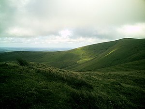
 Foel Cwmcerwyn from Foel Feddau | |||
| Range: | Preseli | ||
| Summit: | 1,760 feet SN09413116 51°56’46"N, 4°46’28"W | ||
Foel Cwmcerwyn is the highest mountain of the Preseli Hills and at 1,760 feet its summit is Pembrokeshire's highest point too.
The mountain lies within the borders of the Pembrokeshire Coast National Park although it is seven miles from the sea. A path leads to the summit from the village of Rosebush in the south-west. A trig point and a number of cairns are dotted across the summit area, and there is a disused quarry on the hill's eastern slopes.
Outside links
- Computer generated summit panoramas Foel Cwmcerwyn index
- www.geograph.co.uk Photos of Foel Cwmcerwyn and surrounding area