Fodderty
| Fodderty Gaelic: Fodhraitidh | |
| Cromartyshire | |
|---|---|
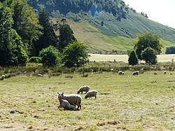
 View towards Knockfarrel from Fodderty | |
| Location | |
| Grid reference: | NH532592 |
| Location: | 57°35’57"N, 4°27’29"W |
| Data | |
| Post town: | Dingwall |
| Postcode: | IV15 |
| Local Government | |
| Council: | Highland |
Fodderty is a small hamlet in Cromartyshire, near the east coast and close to Dingwall, Ross-shire's county town. The wider parish of Fodderty lies mostly in Ross-shire, but encompasses two of the parcels of Cromartyshire, including the southernmost point of the county in Blackmuir Wood to the south of Strathpeffer. It has a total population of 2,818.
The small hamlet of Bottacks is located a mile to the west of Fodderty hamlet and just to the east is Brae or Brea, formed in 1777 from the lands of Davochcarn, Davochmaluag and Davochpollo, long held by a branch of the Mackenzies, for which reason it is a part of Cromartyshire.[1]
The growing town of Dingwall now encroaches on Fodderty.
References
| ("Wikimedia Commons" has material about Fodderty) |
- ↑ William John Watson, Place names of Ross and Cromarty (Inverness Northern Counties Pub. 1904), at page 100
This Cromartyshire article is a stub: help to improve Wikishire by building it up.