File:Wicklow Way Marlay Park Trailhead.jpg
From Wikishire

Size of this preview: 674 × 599 pixels. Other resolution: 270 × 240 pixels.
Original file (3,142 × 2,793 pixels, file size: 4.41 MB, MIME type: image/jpeg)
Summary
| Description |
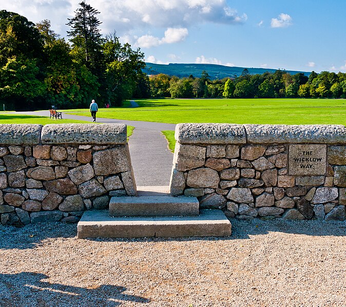
English: The trailhead of the Wicklow Way in Marlay Park, County Dublin, Ireland. The Wicklow Way is a 132km long-distance National Waymarked Trail that runs from Marlay Park across County Wicklow and ends at Clonegal in County Carlow. The trailhead is denoted by a map board (not shown) and a low stone wall with a stile through which walkers pass to make their first step on the Wicklow Way. The wall was erected in 2006 as part of a series of works to mark the 25th anniversary of the opening of the Way. |
| Date | |
| Source | Own work |
| Author | Joe King |
| Permission (Reusing this file) |
This image is licenced under the Creative Commons Attribution-ShareAlike 3.0 Unported. You are free to create, remix, and make derivative works based on the photo, as long as you distribute the derivative work under this ShareAlike Creative Commons license. You must give credit to the owner of the photo. |
| Camera location | | View this and other nearby images on: OpenStreetMap |
|---|
Licensing
I, the copyright holder of this work, hereby publish it under the following license:
This file is licensed under the Creative Commons Attribution-Share Alike 3.0 Unported license.
- You are free:
- to share – to copy, distribute and transmit the work
- to remix – to adapt the work
- Under the following conditions:
- attribution – You must give appropriate credit, provide a link to the license, and indicate if changes were made. You may do so in any reasonable manner, but not in any way that suggests the licensor endorses you or your use.
- share alike – If you remix, transform, or build upon the material, you must distribute your contributions under the same or compatible license as the original.
File history
Click on a date/time to view the file as it appeared at that time.
| Date/Time | Thumbnail | Dimensions | User | Comment | |
|---|---|---|---|---|---|
| current | 19:40, 1 September 2011 | | 3,142 × 2,793 (4.41 MB) | Joe King | Better lit version of the subject |
File usage
The following file is a duplicate of this file (more details):
- File:Wicklow Way Marlay Park Trailhead.jpg from a shared repository
The following page links to this file: