File:Strathclyde.kingdom.influence.areas.png
From Wikishire
Size of this preview: 409 × 600 pixels. Other resolution: 164 × 240 pixels.
Original file (489 × 717 pixels, file size: 717 KB, MIME type: image/png)
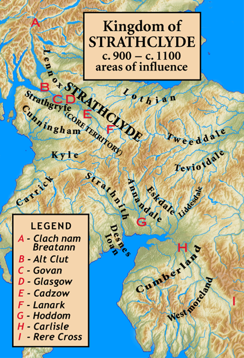
| Description | Kingdom of Strathclyde, areas of influence, c. 900 – c. 1100 |
| Date | |
| Source |
sub area of Image:Uk topo en.jpg plus my modifications Site placement is Alt Clut (at modern Dumbarton), Govan (Govan), Cadzow (Hamilton), and Clach nam Breatann (coordinates given in description of photograph, Image:Clach nam Breatann.jpg) |
| Author | author of source image, plus my modifications (myself) |
| Permission (Reusing this file) |
same permission as the source, plus my permission (see below) |
The map has been created with the Generic Mapping Tools: https://www.generic-mapping-tools.org/ using one or more of these public-domain datasets for the relief:
|

|
Permission is granted to copy, distribute and/or modify this document under the terms of the GNU Free Documentation License, Version 1.2 or any later version published by the Free Software Foundation; with no Invariant Sections, no Front-Cover Texts, and no Back-Cover Texts. A copy of the license is included in the section entitled GNU Free Documentation License. |
I, the copyright holder of this work, hereby publish it under the following license:
This file is licensed under the Creative Commons Attribution-Share Alike 3.0 Unported license.
- You are free:
- to share – to copy, distribute and transmit the work
- to remix – to adapt the work
- Under the following conditions:
- attribution – You must give appropriate credit, provide a link to the license, and indicate if changes were made. You may do so in any reasonable manner, but not in any way that suggests the licensor endorses you or your use.
- share alike – If you remix, transform, or build upon the material, you must distribute your contributions under the same or compatible license as the original.
File history
Click on a date/time to view the file as it appeared at that time.
| Date/Time | Thumbnail | Dimensions | User | Comment | |
|---|---|---|---|---|---|
| current | 13:13, 1 July 2009 | | 489 × 717 (717 KB) | Notuncurious | {{Information |Description=Kingdom of Strathclyde, areas of influence, c. 900 – c. 1100 |Source=sub area of Image:Uk topo en.jpg plus my modifications<br><br> Site placement is Alt Clut (at modern Dumbarton), Govan (Govan), Cadzow (Hamilton), a |
File usage
The following file is a duplicate of this file (more details):
- File:Strathclyde.kingdom.influence.areas.png from a shared repository
The following page links to this file: