File:St Mary and St Peters Way - geograph.org.uk - 289558.jpg
From Wikishire

Size of this preview: 399 × 599 pixels. Other resolution: 160 × 240 pixels.
Original file (426 × 640 pixels, file size: 136 KB, MIME type: image/jpeg)
Summary
| Description |
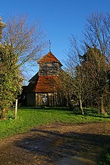
English: St Mary & St Peters Way This is St Mary Mundon some of the structure may possibly date back to the Norman period but the date of founding is unknown. There were later additions in 16th and 18th centuries. It was declared redundant in 1970 but is still consecrated. The ravages of time have not been kind to the structure. However the Friends of Friendless Churches who saved the building from residential conversion in 1975 are still fighting to save it. They need funds urgently to prevent this Essex gem from final collapse. A major building programme to underpin the structure and other repairs is about to begin. This work is being carried out with the help of visitors and the local community. See http://www.friendsoffriendlesschurches.org.uk/churches/mundon/mundon.htm for more info. The St Peters Way long distance path passes through the Churchyard. |
| Date | |
| Source | From geograph.org.uk |
| Author | Glyn Baker |
| Camera location | | View this and other nearby images on: OpenStreetMap |
|---|
_heading:22.00&language=en)
| Object location | | View this and other nearby images on: OpenStreetMap |
|---|
_heading:22.00&language=en)
Licensing

|
This image was taken from the Geograph project collection. See this photograph's page on the Geograph website for the photographer's contact details. The copyright on this image is owned by Glyn Baker and is licensed for reuse under the Creative Commons Attribution-ShareAlike 2.0 license.
|
This file is licensed under the Creative Commons Attribution-Share Alike 2.0 Generic license.
Attribution: Glyn Baker
- You are free:
- to share – to copy, distribute and transmit the work
- to remix – to adapt the work
- Under the following conditions:
- attribution – You must give appropriate credit, provide a link to the license, and indicate if changes were made. You may do so in any reasonable manner, but not in any way that suggests the licensor endorses you or your use.
- share alike – If you remix, transform, or build upon the material, you must distribute your contributions under the same or compatible license as the original.
File history
Click on a date/time to view the file as it appeared at that time.
| Date/Time | Thumbnail | Dimensions | User | Comment | |
|---|---|---|---|---|---|
| current | 20:03, 14 December 2010 | | 426 × 640 (136 KB) | GeographBot | == {{int:filedesc}} == {{Information |description={{en|1=St Mary & St Peters Way This is St Mary Mundon some of the structure may possibly date back to the Norman period but the date of founding is unknown. There were later additions in 16th and 18th ce |
File usage
The following file is a duplicate of this file (more details):
- File:St Mary and St Peters Way - geograph.org.uk - 289558.jpg from a shared repository
The following page links to this file: