File:Severn Barrages map.svg
From Wikishire

Size of this preview: 800 × 579 pixels. Other resolution: 320 × 232 pixels.
Original file (SVG file, nominally 932 × 675 pixels, file size: 118 KB)
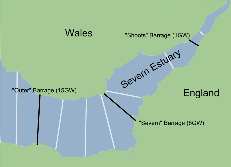
| Description | A map of various plans to put some sort of w:barrage across the w:River Severn, including the three main plans. The numbers in brackets represents peak flow generating capacity, in GW (where one GW represents 1 million watts); in comparison, average UK demand is around 40GW. | ||
| Date | Created 5 March 2010, with information from the period 2007–8. | ||
| Source | Created from w:File:Severn_estuary_barrages.png, a work by w:User:Fig wright released into the public domain. | ||
| Author | Jarry1250 (derivative of w:User:Fig wright) | ||
| Permission (Reusing this file) |
|
File history
Click on a date/time to view the file as it appeared at that time.
| Date/Time | Thumbnail | Dimensions | User | Comment | |
|---|---|---|---|---|---|
| current | 20:26, 5 March 2010 | | 932 × 675 (118 KB) | Jarry1250 | {{Information |Description=A map of various plans to put some sort of w:barrage across the w:River Severn, including the three main plans. The numbers in brackets represents peak flow generating capacity, in GW (where one GW represents 1 millio |
File usage
The following file is a duplicate of this file (more details):
- File:Severn Barrages map.svg from a shared repository
The following page links to this file: