File:Prima Europae tabula (7537877008).jpg
From Wikishire

Size of this preview: 785 × 600 pixels. Other resolution: 314 × 240 pixels.
Original file (2,000 × 1,528 pixels, file size: 2.91 MB, MIME type: image/jpeg)
Summary
| Description |
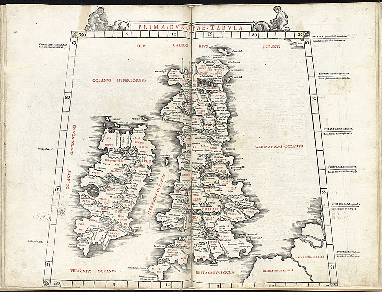
English: The 1st European Map (Prima Europae Tabula) from Jacopo Pencio's edition of Ptolemy's Geography, depicting Great Britain and Ireland, with the position of Scotland corrected from the original. Zoom into this map at maps.bpl.org. Location: British Isles, Ireland Dimension: 37 x 42 cm. Scale: [c. 1:3,900,000] Call Number: G1005 .P7 1511 Latina: In prima Tabula: Iuernia insula & Albion insula Brictannicae. |
| Date | |
| Source |
|
| Author | Ptolemy |
| Other versions |
|
_(14759469056).jpg)
.jpg)
Licensing
This file is licensed under the Creative Commons Attribution 2.0 Generic license.
- You are free:
- to share – to copy, distribute and transmit the work
- to remix – to adapt the work
- Under the following conditions:
- attribution – You must give appropriate credit, provide a link to the license, and indicate if changes were made. You may do so in any reasonable manner, but not in any way that suggests the licensor endorses you or your use.
| This image, originally posted to Flickr, was reviewed on 21 August 2013 by the administrator or reviewer File Upload Bot (Magnus Manske), who confirmed that it was available on Flickr under the stated license on that date. |
File history
Click on a date/time to view the file as it appeared at that time.
| Date/Time | Thumbnail | Dimensions | User | Comment | |
|---|---|---|---|---|---|
| current | 03:59, 21 August 2013 | | 2,000 × 1,528 (2.91 MB) | File Upload Bot (Magnus Manske) | Transferred from Flickr by User:tm |
File usage
The following file is a duplicate of this file (more details):
.jpg)
- File:Prima Europae tabula (7537877008).jpg from a shared repository
The following page links to this file:
.jpg)
.jpg)
.jpg&action=edit&redlink=1)
.jpg)
.jpg&action=info)