File:Plaque atop Snaefell Mountain - Isle of Man - kingsley - 24-JUN-09.jpg
From Wikishire

Size of this preview: 800 × 600 pixels. Other resolution: 320 × 240 pixels.
Original file (2,560 × 1,920 pixels, file size: 1.09 MB, MIME type: image/jpeg)
Summary
| Description |
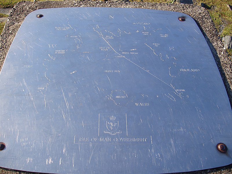
English: A rock cairn atop Snaefell, standing beside to the geodetic marker indicating the true mountain summit, has this plaque affixed on top. It indicates the position of the Isle of Man on the Irish Sea relative to the five kingdoms one can view on a clear day: Mann, Scotland, Ireland, Wales, and England. It also provides the distances from Snaefell to five points: 31 miles to the Mull of Galloway (Scotland), 51 miles to Scafell (England), 66 miles to the Mountains of Mourne (Northern Ireland), 85 miles to Liverpool (England), and 97 miles to Dublin (Ireland). |
| Date | |
| Source | Own work |
| Author | Gregory J Kingsley |
54°15′47.6″N 4°27′42.1″W / 54.263222°N 4.461694°W
| Camera location | | View this and other nearby images on: OpenStreetMap |
|---|
Licensing
I, the copyright holder of this work, hereby publish it under the following licenses:
This file is licensed under the Creative Commons Attribution-Share Alike 3.0 Unported license.
- You are free:
- to share – to copy, distribute and transmit the work
- to remix – to adapt the work
- Under the following conditions:
- attribution – You must give appropriate credit, provide a link to the license, and indicate if changes were made. You may do so in any reasonable manner, but not in any way that suggests the licensor endorses you or your use.
- share alike – If you remix, transform, or build upon the material, you must distribute your contributions under the same or compatible license as the original.

|
Permission is granted to copy, distribute and/or modify this document under the terms of the GNU Free Documentation License, Version 1.2 or any later version published by the Free Software Foundation; with no Invariant Sections, no Front-Cover Texts, and no Back-Cover Texts. A copy of the license is included in the section entitled GNU Free Documentation License. |
You may select the license of your choice.
File history
Click on a date/time to view the file as it appeared at that time.
| Date/Time | Thumbnail | Dimensions | User | Comment | |
|---|---|---|---|---|---|
| current | 17:44, 16 August 2009 | | 2,560 × 1,920 (1.09 MB) | Gregory J Kingsley | {{Information |Description={{en|1=A rock cairn atop Snaefell, standing beside to the geodetic marker indicating the true mountain summit, has this plaque affixed on top. It indicates the position of the Isle of Man on the Irish Sea relative to the five k |
File usage
The following file is a duplicate of this file (more details):
- File:Plaque atop Snaefell Mountain - Isle of Man - kingsley - 24-JUN-09.jpg from a shared repository
The following page links to this file: