File:Lanteglos castle goff panorama 1.jpg
From Wikishire

Size of this preview: 800 × 168 pixels. Other resolution: 320 × 67 pixels.
Original file (6,665 × 1,400 pixels, file size: 5.06 MB, MIME type: image/jpeg)
Summary
| Description |
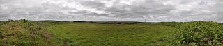
English: Hill Fort Castle Goff, near the old settlement Delinuth Camp, on a hill above Lanteglos-by-Camelford, Cornwall, England, UK
Deutsch: Der Ringwall Castle Goff, wahrscheinlich zu den Siedlungsresten Delinuth Camp gehörend, bei Lanteglos-By-Camelford, Cornwall, England, Großbritannien |
| Date | |
| Source | Own work |
| Author | Dietrich Krieger |
| Camera location | | View this and other nearby images on: OpenStreetMap |
|---|

|
NOTE: This image is a panorama consisting of multiple frames that were merged or stitched in software. As a result, this image necessarily underwent some form of digital manipulation. These manipulations may include blending, blurring, cloning, and colour and perspective adjustments. As a result of these adjustments, the image content may be slightly different from reality at the points where multiple images were combined. This manipulation is often required due to lens, perspective, and parallax distortions.
|
Licensing
I, the copyright holder of this work, hereby publish it under the following licenses:

|
Permission is granted to copy, distribute and/or modify this document under the terms of the GNU Free Documentation License, Version 1.2 or any later version published by the Free Software Foundation; with no Invariant Sections, no Front-Cover Texts, and no Back-Cover Texts. A copy of the license is included in the section entitled GNU Free Documentation License. |
This file is licensed under the Creative Commons Attribution-Share Alike 3.0 Unported, 2.5 Generic, 2.0 Generic and 1.0 Generic license.
- You are free:
- to share – to copy, distribute and transmit the work
- to remix – to adapt the work
- Under the following conditions:
- attribution – You must give appropriate credit, provide a link to the license, and indicate if changes were made. You may do so in any reasonable manner, but not in any way that suggests the licensor endorses you or your use.
- share alike – If you remix, transform, or build upon the material, you must distribute your contributions under the same or compatible license as the original.
You may select the license of your choice.
File history
Click on a date/time to view the file as it appeared at that time.
| Date/Time | Thumbnail | Dimensions | User | Comment | |
|---|---|---|---|---|---|
| current | 19:37, 15 September 2010 | 6,665 × 1,400 (5.06 MB) | DKrieger | {{Information |Description={{en|1=Hill Fort Castle Goff, near the old settlement Delinuth Camp, on a hill above Lanteglos-by-Camelford, Panorama}} {{de|1=Der Ringwall Castle Goff, wahrscheinlich zu den Siedlungsresten Delinuth Camp gehörend, bei Lanteglo |
File usage
The following file is a duplicate of this file (more details):
- File:Lanteglos castle goff panorama 1.jpg from a shared repository
The following page links to this file: