File:Irish Sea 4.82844W 53.54821N.png
From Wikishire

Size of this preview: 800 × 527 pixels. Other resolution: 320 × 211 pixels.
Original file (992 × 653 pixels, file size: 912 KB, MIME type: image/png)
Summary
| Description |
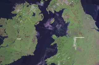
English: Irish Sea. Satellite view. Blue Marble Next Generation image.
Español: Mapa del Mar de Irlanda en el proyecto Blue Marble de la NASA. |
| Date | 20 May 2005 (upload date) |
| Source | Satellite imagery taken from NASA World Wind software (by screenshot) |
| Author | NASA |
| Other versions | Derivative works of this file: Irish Sea satellite image.jpg |
| Object location | | View this and other nearby images on: OpenStreetMap |
|---|
Licensing
| This image is in the public domain because it is a screenshot from NASA’s globe software World Wind using a public domain layer, such as Blue Marble, MODIS, Landsat, SRTM, USGS or GLOBE.
|
 |
File history
Click on a date/time to view the file as it appeared at that time.
| Date/Time | Thumbnail | Dimensions | User | Comment | |
|---|---|---|---|---|---|
| current | 19:09, 20 May 2005 | | 992 × 653 (912 KB) | Jelte | NASA World-Wind screenshot. {{PD-USGov-NASA}} |
File usage
The following file is a duplicate of this file (more details):
- File:Irish Sea 4.82844W 53.54821N.png from a shared repository
The following page links to this file: