File:Downfield windmill, Soham - geograph.org.uk - 252316.jpg
From Wikishire

Size of this preview: 400 × 600 pixels. Other resolution: 160 × 240 pixels.
Original file (427 × 640 pixels, file size: 64 KB, MIME type: image/jpeg)
This is a photo of listed building number 1331761. |
Summary
| Description |
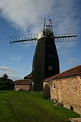
English: Downfield windmill, Soham The future of this historic windmill is in doubt after it was revealed that restoration would cost £100,000. Downfield Windmill in Fordham Road, Soham, has been placed on the English Heritage Buildings At Risk register, the annually published list which aims to identify buildings at risk through neglect and decay, or vulnerable to becoming so. The mill, previously in working order, was opened as a tourist attraction until it suffered massive storm damage in January and February of 2001. |
| Date | |
| Source | From geograph.org.uk |
| Author | Bob Jones |
| Attribution (required by the license) | Bob Jones / Downfield windmill, Soham / |
| Camera location | | View this and other nearby images on: OpenStreetMap |
|---|
_heading:247.00&language=en)
| Object location | | View this and other nearby images on: OpenStreetMap |
|---|
_heading:247.00&language=en)
Licensing

|
This image was taken from the Geograph project collection. See this photograph's page on the Geograph website for the photographer's contact details. The copyright on this image is owned by Bob Jones and is licensed for reuse under the Creative Commons Attribution-ShareAlike 2.0 license.
|
This file is licensed under the Creative Commons Attribution-Share Alike 2.0 Generic license.
Attribution: Bob Jones
- You are free:
- to share – to copy, distribute and transmit the work
- to remix – to adapt the work
- Under the following conditions:
- attribution – You must give appropriate credit, provide a link to the license, and indicate if changes were made. You may do so in any reasonable manner, but not in any way that suggests the licensor endorses you or your use.
- share alike – If you remix, transform, or build upon the material, you must distribute your contributions under the same or compatible license as the original.
File history
Click on a date/time to view the file as it appeared at that time.
| Date/Time | Thumbnail | Dimensions | User | Comment | |
|---|---|---|---|---|---|
| current | 16:52, 25 August 2010 | | 427 × 640 (64 KB) | GeographBot | == {{int:filedesc}} == {{Information |description={{en|1=Downfield windmill, Soham The future of this historic windmill is in doubt after it was revealed that restoration would cost £100,000. Downfield Windmill in Fordham Road, Soham, has been placed on |
File usage
The following file is a duplicate of this file (more details):
- File:Downfield windmill, Soham - geograph.org.uk - 252316.jpg from a shared repository
The following page links to this file: