File:Cowal peninsula landsat.jpg
From Wikishire

Size of this preview: 444 × 599 pixels. Other resolution: 178 × 240 pixels.
Original file (948 × 1,280 pixels, file size: 340 KB, MIME type: image/jpeg)
Summary
| Description |
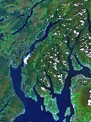
The Cowal peninsula, Argyllshire PD Landsat images, prepared using NASA World Wind. |
| Source | Satellite imagery taken from NASA World Wind software (by screenshot) |
| Author | Photograph: NASA |
| Other versions | Cowal_peninsula_landsat.png |
Licensing
| This image is in the public domain because it is a screenshot from NASA’s globe software World Wind using a public domain layer, such as Blue Marble, MODIS, Landsat, SRTM, USGS or GLOBE.
|
 |
Original upload log
The original description page was here. All following user names refer to en.wikipedia.
- 2005-07-04 12:22 Finlay McWalter 948×1280× (2298715 bytes) Scotland's [[Cowal]] peninsula. PD Landsat images, prepared using NASA World Wind. {{PD-USGov-NASA}}
File history
Click on a date/time to view the file as it appeared at that time.
| Date/Time | Thumbnail | Dimensions | User | Comment | |
|---|---|---|---|---|---|
| current | 06:10, 25 June 2014 | | 948 × 1,280 (340 KB) | Hogweard | {{Information |Description=The Cowal peninsula, Argyllshire PD Landsat images, prepared using NASA World Wind.}} |Source=Transferred from [http://en.wikipedia.org en.wikipedia]; transferred to Commons by User:Kafuffle using [http://t... |
File usage
The following file is a duplicate of this file (more details):
- File:Cowal peninsula landsat.jpg from a shared repository
The following page links to this file: