File:ChathamDarland3029.JPG
From Wikishire

Size of this preview: 800 × 600 pixels. Other resolution: 320 × 240 pixels.
Original file (2,016 × 1,512 pixels, file size: 1.08 MB, MIME type: image/jpeg)
| Description |
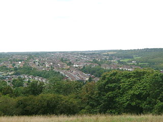
The Darland Banks are unimproved chalk grassland, in Chatham, Kent. Bordering on Gillingham they form the northern slopes of the Luton and Capstone Valleys This shot was taken from the top of Ash Tree Lane by Star Mill Lane. Star Mill or Upper Chatham Hill Mill was dismantled in 1924. We are looking over Luton Village. Rows of victorian terraced houses follow the contour lines. We can see all syles of 20th century housing. To the right are the fields of the Daisy Banks and Coney banks with Fort Luton in the trees.
|
||||
| Date | 18 September | ||||
| Source | Own work | ||||
| Author | Clem Rutter, Rochester Kent | ||||
| Permission (Reusing this file) |
Own work, attribution required (Multi-license with GFDL and Creative Commons CC-BY 2.5) |
I, the copyright holder of this work, hereby publish it under the following licenses:

|
Permission is granted to copy, distribute and/or modify this document under the terms of the GNU Free Documentation License, Version 1.2 or any later version published by the Free Software Foundation; with no Invariant Sections, no Front-Cover Texts, and no Back-Cover Texts. A copy of the license is included in the section entitled GNU Free Documentation License. |
| This file is licensed under the Creative Commons Attribution-Share Alike 3.0 Unported license. | ||
| ||
| This licensing tag was added to this file as part of the GFDL licensing update. |
This file is licensed under the Creative Commons Attribution 2.5 Generic license.
- You are free:
- to share – to copy, distribute and transmit the work
- to remix – to adapt the work
- Under the following conditions:
- attribution – You must give appropriate credit, provide a link to the license, and indicate if changes were made. You may do so in any reasonable manner, but not in any way that suggests the licensor endorses you or your use.
You may select the license of your choice.
File history
Click on a date/time to view the file as it appeared at that time.
| Date/Time | Thumbnail | Dimensions | User | Comment | |
|---|---|---|---|---|---|
| current | 20:24, 18 September 2007 | | 2,016 × 1,512 (1.08 MB) | ClemRutter | {{Information |Description=The Darland Banks are unimproved chalk grassland, in Chatham, Kent. Bordering on Gillingham they form the northern slopes of the Luton and Capstone Valleys This shot was taken from the top of Ash Tree Lane by Star Mill Lane. St |
File usage
The following file is a duplicate of this file (more details):
- File:ChathamDarland3029.JPG from a shared repository
The following page links to this file: