File:All Saints Church Adlingfleet.jpg
From Wikishire
No higher resolution available.
All_Saints_Church_Adlingfleet.jpg (640 × 484 pixels, file size: 130 KB, MIME type: image/jpeg)
This is a photo of listed building number 1083144. |
Summary
| Description |
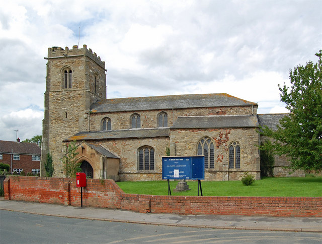
English: All Saints' parish church, Adlingfleet, East Riding of Yorkshire, England seen from the south. "Adlingfleet was the third richest 'living' in England. This becomes no less astonishing but more significant when we discover that numbers one and two were Lindisfarne and Bamburgh. They were the ecclesiastical and regal headquarters of the Northumbrian Kingdom and the wealth of those two churches must have been based not on the intrinsic economic prosperity (or even the size of the population) of the area but on the generosity of the Royal endowments. The same story can be told of the Aetheling's Church at Adlingfleet. The mystery of the Church's mediaeval wealth finds some explanation if Adlingfleet was a Royal Saxon centre of some ecclesiastical importance." See link for further information. |
| Date | |
| Source | From geograph.org.uk |
| Author | David Wright |
| Permission (Reusing this file) |
Creative Commons Attribution Share-alike license 2.0 |
| Camera location | | View this and other nearby images on: OpenStreetMap |
|---|
| Object location | | View this and other nearby images on: OpenStreetMap |
|---|
_region:GB-ENG_heading:315.00&language=en)
Licensing

|
This image was taken from the Geograph project collection. See this photograph's page on the Geograph website for the photographer's contact details. The copyright on this image is owned by David Wright and is licensed for reuse under the Creative Commons Attribution-ShareAlike 2.0 license.
|
This file is licensed under the Creative Commons Attribution-Share Alike 2.0 Generic license.
Attribution: David Wright
- You are free:
- to share – to copy, distribute and transmit the work
- to remix – to adapt the work
- Under the following conditions:
- attribution – You must give appropriate credit, provide a link to the license, and indicate if changes were made. You may do so in any reasonable manner, but not in any way that suggests the licensor endorses you or your use.
- share alike – If you remix, transform, or build upon the material, you must distribute your contributions under the same or compatible license as the original.
File history
Click on a date/time to view the file as it appeared at that time.
| Date/Time | Thumbnail | Dimensions | User | Comment | |
|---|---|---|---|---|---|
| current | 19:23, 21 October 2007 | | 640 × 484 (130 KB) | Keith D | {{Information |Description=All Saints Church, Adlingfleet in the East Riding of Yorkshire |Source=Geograph project http://www.geograph.org.uk/photo/507343 |Date=Friday, 27 July, 2007 |Author=David Wrigh |
File usage
The following file is a duplicate of this file (more details):
- File:All Saints Church Adlingfleet.jpg from a shared repository
The following page links to this file: