Felmersham
| Felmersham | |
| Bedfordshire | |
|---|---|
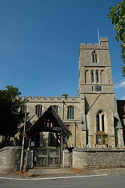
 St Mary's Church, Felmersham | |
| Location | |
| Grid reference: | SP990495 |
| Location: | 52°12’60"N, 0°33’0"W |
| Data | |
| Post town: | Bedford |
| Postcode: | MK43 |
| Dialling code: | 01234 |
| Local Government | |
| Council: | Bedford |
| Parliamentary constituency: |
North East Bedfordshire |
Felmersham is a village in Bedfordshire, on the bank of the River Great Ouse, about 7 miles northwest of Bedford. The Great Ouse curves gracefully around the parish to the north, east and south.
Nearby villages include Sharnbrook, Odell, Pavenham and Milton Ernest.
Felmersham is recorded in the Domesday Book of 1086 as a parish within the Willey Hundred.[1] This is one of the places in Bedfordshire where flint has been mined, leaving little lakes in the tight loop of the river here.
The parish church is St Mary. John de Burnham, later Lord High Treasurer of Ireland, was parish priest here in the 1330s.
The village gave its name to HMS Felmersham, a Ham class minesweeper.
Felmersham has no shop or Post Office but does have one public house, The Sun. Two previous pubs closed in the 1990s; The Plough in 1991 and The Six Ringers in 1995.
Outside links
| ("Wikimedia Commons" has material about Felmersham) |