Difference between revisions of "Fallières Coast"
(Created page with "Location of the Fallières Coast {{territory|British Antarctic Territory}} The '''Fallières Coast''' is a portion of the...") |
(→References) |
||
| Line 18: | Line 18: | ||
{{DEFAULTSORT:Fallieres Coast}} | {{DEFAULTSORT:Fallieres Coast}} | ||
| + | {{Catself}} | ||
[[Category:Coasts of Graham Land]] | [[Category:Coasts of Graham Land]] | ||
Revision as of 12:40, 13 July 2020
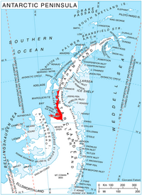
The Fallières Coast is a portion of the west coast of Graham Land (the northern part of the Antarctic Peninsula, in the British Antarctic Territory. It extends between the head of Bourgeois Fjord and Cape Jeremy, lying along he coast of Marguerite Bay and the Wordie Ice Shelf.
On the south, this coast is joined by Rymill Coast of Palmer Land, and in the north by Graham Land's Loubet Coast.
The Fallières Coast was first explored in January 1909 by the [[French Antarctic Expedition of 1908–10 under J.B. Charcot, who named it Terre Fallières after Armand Fallières, then President of France, who had approved the appointment of the Commission Scientifique for the French Antarctic Expedition.
A resurvey of the whole coast by the British Graham Land Expedition in 1936-37 led to its redefinition and the adoption of the name 'Fallières Coast'.
Location
- Location map: 68°33’15"S, 66°43’43"W
References
- Gazetteer and Map of The British Antarctic Territory: Fallières Coast
