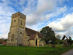
Faccombe
| Faccombe | |
| Hampshire | |
|---|---|
 Faccombe Parish Church | |
| Location | |
| Grid reference: | SU391579 |
| Location: | 51°19’9"N, 1°26’26"W |
| Data | |
| Population: | 146 (2011) |
| Post town: | Andover |
| Postcode: | SP11 |
| Dialling code: | 01264 |
| Local Government | |
| Council: | Test Valley |
| Parliamentary constituency: |
North West Hampshire |
Faccombe is a village in Hampshire, just south of the border with Berkshire, formed here by the ancient track along the escarpment marked by the Wayfarer's Walk. and is situated on the Hampshire Downs. Its nearest Hampshire town is Andover, eight miles away, while Newbury in Berkshire is six miles from the village.
The village was originally called "Faccombe Upstrete" in the Middle Ages to distinguish it from Netherton, Hampshire, a village lower in the valley.[1]
The village has an inn, The Jack Russell Inn.[2]
Landmarks
A large part of the parish is part of the Faccombe Estate which is a shooting estate,[3] with a prominent wind turbine. The estate was formerly owned by Brigadier Timothy Landon.
Immediately north of the village are some of the highest summits in Hampshire: Combe Hill (942 feet) is due north of the village and to its east Pilot Hill (938 feet), while Hampshire's county top, Walbury Hill (974 feet), is immediately north-west of Combe Hill, two and a half miles from Faccombe.
| ("Wikimedia Commons" has material about Faccombe) |
References
- ↑ Fairbrother, J.R. (1990). Faccombe Netherton: Excavations of a Saxon and Mediæval Manorial Complex. London: British Museum Publications. pp. 40.
- ↑ "The Good Pub Guide". Penguin Random House. 2019. https://thegoodpubguide.co.uk/pub/sp11+0ds/jack+russell/.
- ↑ The Field http://www.thefield.co.uk/shooting/the-50-best-sporting-estates-22216