Evenlode
- Not to be confused with River Evenlode
| Evenlode | |
| Worcestershire | |
|---|---|
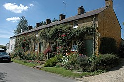
 Cottages in Evenlode | |
| Location | |
| Grid reference: | SP223290 |
| Location: | 51°57’33"N, 1°40’33"W |
| Data | |
| Population: | 150 (2016 est.) |
| Post town: | Moreton-in-Marsh |
| Postcode: | GL56 |
| Local Government | |
| Council: | Cotswold |
Evenlode is a village in the heart of the Cotswolds, in one of the many detached parts of Worcestershire, in the Oswaldslow Hundred, caught between the bounds of Gloucestershire and Oxfordshire. The northern point of this bubble of Worcestershire marks a meeting of four shires: Worcestershire, Gloucestershire, Oxfordshire and Warwickshire, and here stands the Four shire stone.
The River Evenlode, which shares its name, forms the parish's western boundary.
To the north-west is the little Gloucestershire town of Moreton-in-Marsh and to the south-west of Stow-on-the-Wold. Chipping Norton, in Oxfordshire, is to the east.
Parish church
The parish was granted before the 10th century to Worcester Priory, latterly as part of the manor of Blockley; the priory's scattered lands formed many of the detached parts of the County of Worcester.
The parish church, St Edward King & Martyr, was built in the 12th century and restored in 1879. It is a is a Grade II* Listed Building.[1] The parish is within the Diocese of Gloucester.
Outside links
References
- ↑ National Heritage List 1089794: Church of St Edward, Evenlode
- A History of the County of Worcestershire - Volume 3 pp 347–352: Parishes: Evenlode (Victoria County History)